Waterway information

Kind:
Inland
Driving areas:
🌊 North Sea🇬🇧 United Kingdom
Length:
90 km¹
¹River kilometers or bank length recorded in NavShip, including river arms and harbor entrances.
Availability:
Completely recorded
Recent Update: 10.04.2025²
² This date indicates when an adjustment last took place in the course of the body of water
Recorded:
Locks: 1
Harbours / marinas: 4
Bridges: 1
Berths: 3
Slipways: 1
Fuelstations: 1
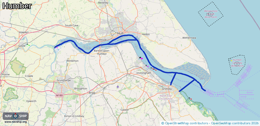
Route:
Please wait, loading route graphic...
Request waterway overview map with symbol legend here (Link).
Information about data associated with this body of water (10 available):
Data by OpenSeaMap (c) OSM contributors, www.openseamap.org
| # | Kind | Coordinates | Name | Information |
|---|---|---|---|---|
| 1 | Marina | 53.73946,-0.33784 | 2023-02-07T15:58:17Z | Hull Marina +44 1482 609960 https://www.bwml.co.uk/marinas/hull_marina |
| 2 | Marina | 53.73991,-0.34017 | 2023-02-07T15:58:17Z | Hull Marina |
| 3 | Marina | 53.57801,-0.06787 | 2024-06-11T17:54:06Z | Humber Cruising Association Ltd +44 1472 268 424 http://www.hcagrimsby.co.uk |
| 4 | Marina | 53.57556,-0.07978 | 2024-06-08T12:35:01Z | Grimsby & Cleethorpes Yacht Club [email protected] +44 1472 356 678 https://www.gcyc.co.uk/ |
| 5 | Bridge | 53.70685,-0.45006 | Unknown | Clearance height: 2025-11-16T00:02:16Z m Maximum passage width: 29 m Movable bridge (e.g. lifting bridge or drawbridge) suspension |
| 6 | Slipway | 53.55683,-0.02207 | small_craft_facility | 2021-01-14T08:40:44Z |
| 7 | Berth | 53.58043,0.10187 | 2014-08-19T14:36:56Z | small_craft |
| 8 | Berth | 53.59497,0.0255 | 2015-06-21T18:53:23Z | Hawke Anchorage |
| 9 | Berth | 53.62557,-0.04695 | 2014-08-19T14:38:35Z | small_craft |
| 10 | Fuel station | 53.73856,-0.33735 | 2013-05-07T16:14:48Z | |
| 10 | Fuel station | 53.73856,-0.33735 | 2013-05-07T16:14:48Z |