Waterway information

Kind:
Sea
Driving areas:
🇩🇪 Germany
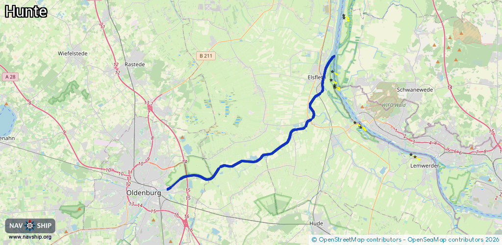
Length:
23.4 km¹
¹River kilometers or bank length recorded in NavShip, including river arms and harbor entrances.
Availability:
Completely recorded
Recent Update: 31.03.2025²
² This date indicates when an adjustment last took place in the course of the body of water
Recorded:
Locks: 0
Harbours / marinas: 2
Bridges: 3
Berths: 0
Slipways: 0
Fuelstations: 0
Route:
Please wait, loading route graphic...
Request waterway overview map with symbol legend here (Link).
Information about data associated with this body of water (5 available):
Data by OpenSeaMap (c) OSM contributors, www.openseamap.org
| # | Kind | Coordinates | Name | Information |
|---|---|---|---|---|
| 1 | Marina | 53.14975,8.30667 | 2020-12-01T11:45:13Z | Iprump |
| 2 | Marina | 53.23469,8.46494 | 2021-06-12T08:38:20Z | Stadthafen Elsfleth |
| 3 | Bridge | 53.15294,8.27453 | Unknown | Clearance height: 2012-12-31T13:32:42Z m Maximum passage width: 26 m Movable bridge (e.g. lifting bridge or drawbridge) fixed http://upload.wikimedia.org/wikipedia/commons/c/c0/Osthafen_Oldenburg_A29.JPG |
| 4 | Bridge | 53.2213,8.45855 | Unknown | Clearance height: 2024-08-08T21:17:03Z m Maximum passage width: 4.4 m Movable bridge (e.g. lifting bridge or drawbridge) fixed |
| 5 | Bridge | 53.24864,8.47425 | Unknown | Clearance height: 2025-04-03T20:16:35Z m Movable bridge (e.g. lifting bridge or drawbridge) opening 07:00-07:01,08:00-08:01,09:00-09:01,10:00-10:01,11:00-11:01,12:00-12:01,13:00-13:01,14:00-14:01,15:00-15:01,16:00-16:01,17:00-17:01,18:00-18:01,19:00-19:01,20:00-20:01 http://upload.wikimedia.org/wikipedia/commons/3/3c/Huntesperrwerk.jpg |