Waterway information

Kind:
Inland
Driving areas:
🇩🇪 Germany
Length:
5 km¹
¹River kilometers or bank length recorded in NavShip, including river arms and harbor entrances.
Availability:
Completely recorded
Recent Update: 20.06.2023²
² This date indicates when an adjustment last took place in the course of the body of water
Recorded:
Locks: 0
Harbours / marinas: 3
Bridges: 0
Berths: 2
Slipways: 1
Fuelstations: 0
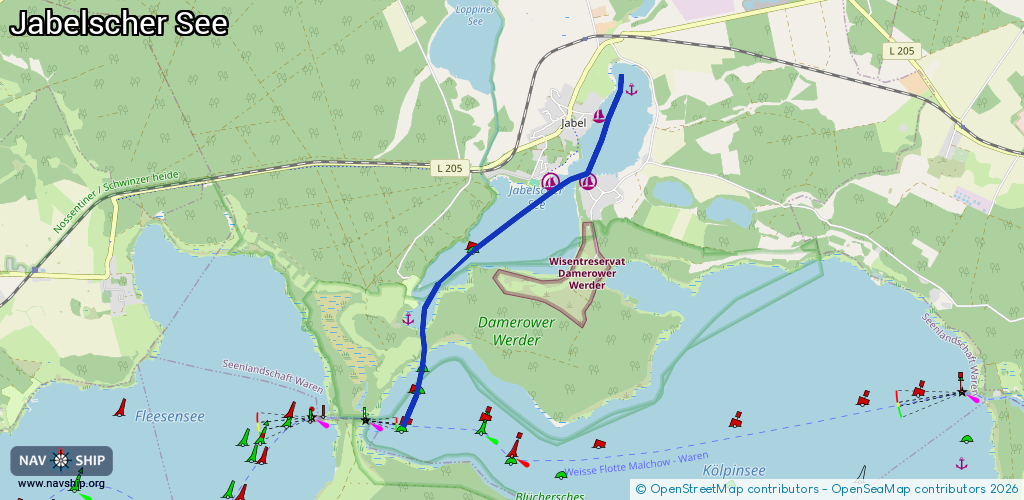
Route:
Please wait, loading route graphic...
Request waterway overview map with symbol legend here (Link).
Information about data associated with this body of water (6 available):
Data by OpenSeaMap (c) OSM contributors, www.openseamap.org
| # | Kind | Coordinates | Name | Information |
|---|---|---|---|---|
| 1 | Marina | 53.5306,12.54101 | 2019-03-26T07:19:47Z | Maribell Yachthafen [email protected] +49 39929 70500 https://www.maribell.de/ |
| 2 | Marina | 53.53066,12.54742 | 2012-09-23T22:31:04Z | Fischerei Damerow |
| 3 | Marina | 53.53751,12.54932 | 2013-01-01T19:07:44Z | |
| 4 | Slipway | 53.53072,12.54061 | small_craft_facility | 2015-08-09T09:10:53Z Slipanlage Maribell |
| 5 | Berth | 53.51662,12.51656 | 2016-09-26T08:32:50Z | |
| 6 | Berth | 53.54001,12.5549 | 2012-09-23T22:31:05Z |