Waterway information

Kind:
Inland
Driving areas:
🇳🇱 Netherlands
Length:
9.2 km¹
¹River kilometers or bank length recorded in NavShip, including river arms and harbor entrances.
Availability:
Completely recorded
Recent Update: 23.04.2025²
² This date indicates when an adjustment last took place in the course of the body of water
Recorded:
Locks: 1
Harbours / marinas: 3
Bridges: 7
Berths: 0
Slipways: 0
Fuelstations: 1
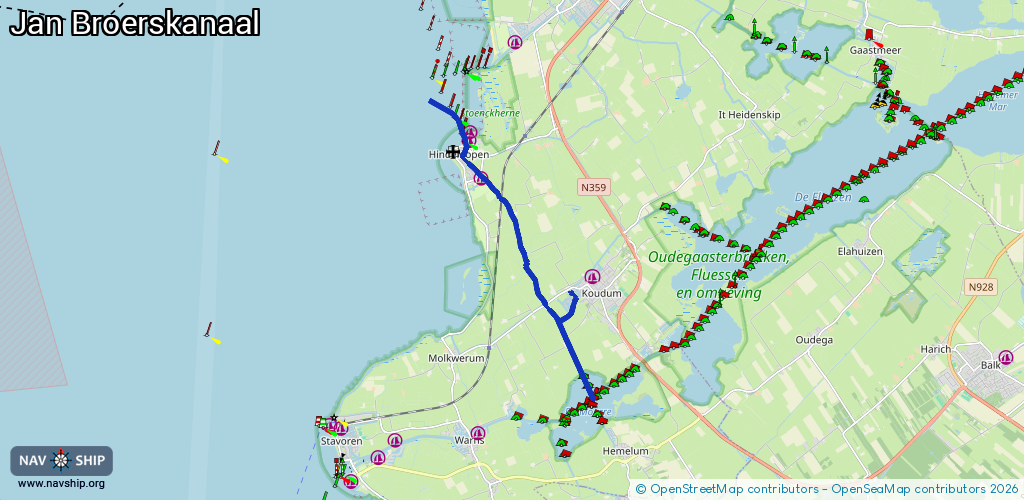
Route:
Please wait, loading route graphic...
Request waterway overview map with symbol legend here (Link).
Information about data associated with this body of water (11 available):
Data by OpenSeaMap (c) OSM contributors, www.openseamap.org
| # | Kind | Coordinates | Name | Information |
|---|---|---|---|---|
| 1 | Marina | 52.94714,5.40418 | 2022-12-06T14:46:12Z | Jachthaven Hindeloopen |
| 2 | Marina | 52.94502,5.40348 | 2025-09-24T15:09:48Z | Jachthaven Hindeloopen https://www.skipsmaritiem.nl/nl/jachthavens/hindeloopen |
| 3 | Marina | 52.93755,5.40811 | 2022-12-06T14:46:12Z | |
| 4 | Bridge | 52.94378,5.40259 | 4.5 | Clearance height: 2020-06-20T12:31:22Z m Maximum passage width: 2.35 m Movable bridge (e.g. lifting bridge or drawbridge) opening |
| 5 | Bridge | 52.94303,5.40208 | Unknown | Clearance height: 2020-10-07T13:48:40Z m fixed |
| 6 | Bridge | 52.94257,5.4031 | Unknown | Clearance height: 2020-10-07T13:48:40Z m fixed |
| 7 | Bridge | 52.94189,5.40173 | 11.5 | Clearance height: 2015-08-17T15:56:52Z m Maximum passage width: 2.25 m opening |
| 8 | Bridge | 52.93829,5.40781 | 6 | Clearance height: 2015-08-17T15:56:52Z m Maximum passage width: 2.57 m fixed |
| 9 | Bridge | 52.93338,5.41503 | 13.5 | Clearance height: 2015-08-17T15:56:52Z m Maximum passage width: 3 m fixed |
| 10 | Bridge | 52.91134,5.4302 | 8 | Clearance height: 2015-08-17T15:56:50Z m Maximum passage width: 3 m fixed |
| 11 | Fuel station | 52.94471,5.40339 | 2023-04-17T13:35:56Z | |
| 11 | Fuel station | 52.94471,5.40339 | 2023-04-17T13:35:56Z |