Waterway information

Kind:
Inland
Driving areas:
🇩🇪 Germany
Length:
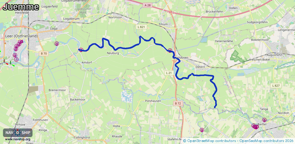
19.4 km¹
¹River kilometers or bank length recorded in NavShip, including river arms and harbor entrances.
Availability:
Completely recorded
Recent Update: 02.11.2021²
² This date indicates when an adjustment last took place in the course of the body of water
Recorded:
Locks: 0
Harbours / marinas: 2
Bridges: 3
Berths: 0
Slipways: 0
Fuelstations: 0
Route:
Please wait, loading route graphic...
Request waterway overview map with symbol legend here (Link).
Information about data associated with this body of water (5 available):
Data by OpenSeaMap (c) OSM contributors, www.openseamap.org
| # | Kind | Coordinates | Name | Information |
|---|---|---|---|---|
| 1 | Marina | 53.223,7.52785 | 2013-01-15T15:56:35Z | WSV Wiltshausen +49 491 71830 http://www.wsv-wiltshausen.de |
| 2 | Marina | 53.22251,7.63379 | 2013-02-08T12:44:06Z | Wassersportclub Jümme Detern [email protected] +49 172 1698118 http://www.wsc-juemme.de |
| 3 | Bridge | 53.21754,7.63983 | Unknown | Clearance height: 2014-04-30T11:46:56Z m Maximum passage width: 4.5 m fixed |
| 4 | Bridge | 53.21664,7.64341 | Unknown | Clearance height: 2025-11-17T08:51:15Z m Movable bridge (e.g. lifting bridge or drawbridge) opening |
| 5 | Bridge | 53.20504,7.66433 | Unknown | Clearance height: 2014-04-30T11:07:54Z m Maximum passage width: 2 m fixed |