Waterway information

Kind:
Inland
Driving areas:
🌊 Baltic Sea🇱🇻 Latvia
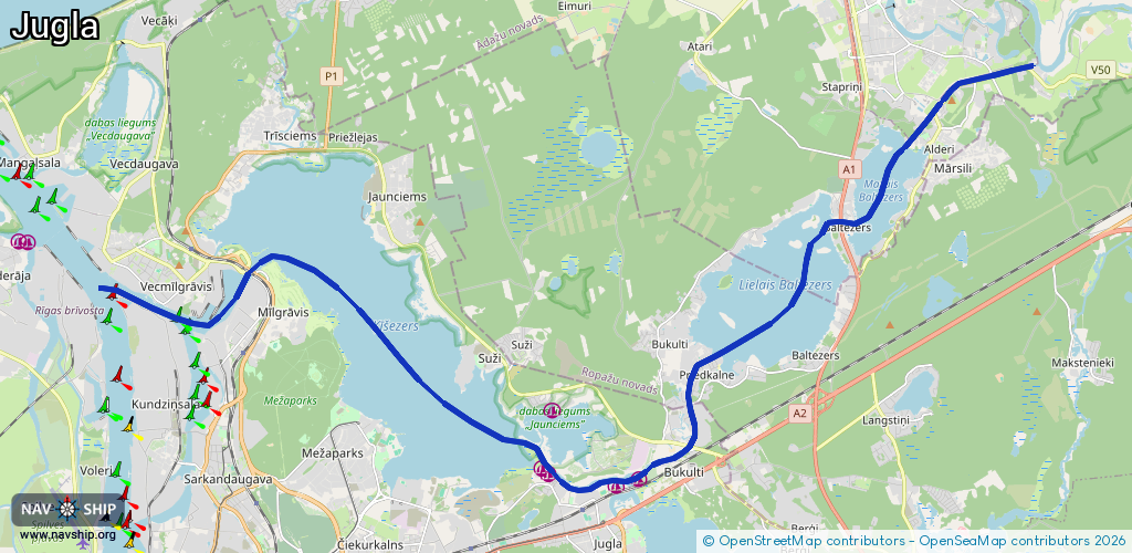
Length:
24.6 km¹
¹River kilometers or bank length recorded in NavShip, including river arms and harbor entrances.
Availability:
Completely recorded
Recent Update: 17.08.2023²
² This date indicates when an adjustment last took place in the course of the body of water
Recorded:
Locks: 0
Harbours / marinas: 5
Bridges: 0
Berths: 0
Slipways: 0
Fuelstations: 0
Route:
Please wait, loading route graphic...
Request waterway overview map with symbol legend here (Link).
Information about data associated with this body of water (5 available):
Data by OpenSeaMap (c) OSM contributors, www.openseamap.org
| # | Kind | Coordinates | Name | Information |
|---|---|---|---|---|
| 1 | Marina | 56.99733,24.25264 | 2023-10-12T07:56:41Z | Individuālo laivu garāžu īpašnieku kooperatīvā sabiedrība Vilnis |
| 2 | Marina | 56.99625,24.24615 | 2023-10-12T07:56:41Z | Airis 1 |
| 3 | Marina | 56.99809,24.22432 | 2021-12-04T21:49:33Z | KS Makšķernieks |
| 4 | Marina | 56.99927,24.22233 | 2022-07-15T19:38:40Z | Marina Malina [email protected] +371 20212123 https://www.marinamalina.eu |
| 5 | Marina | 57.00889,24.22571 | 2021-11-23T17:19:56Z |