Waterway information

Kind:
Inland
Driving areas:
🇩🇪 Germany
Length:
9.6 km¹
¹River kilometers or bank length recorded in NavShip, including river arms and harbor entrances.
Availability:
Completely recorded
Recent Update: 04.04.2025²
² This date indicates when an adjustment last took place in the course of the body of water
Recorded:
Locks: 0
Harbours / marinas: 4
Bridges: 4
Berths: 0
Slipways: 1
Fuelstations: 1
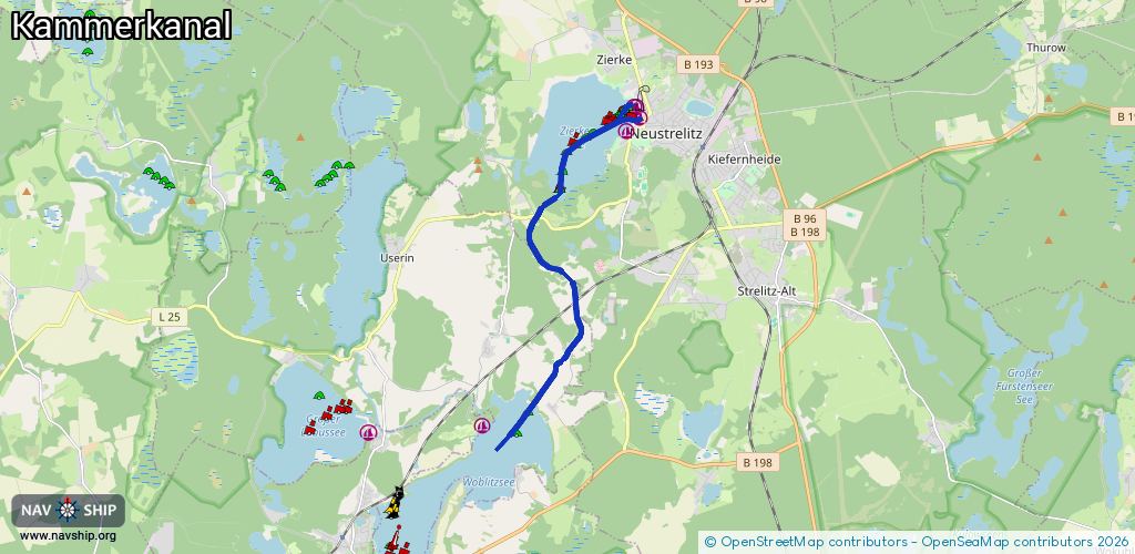
Route:
Please wait, loading route graphic...
Request waterway overview map with symbol legend here (Link).
Information about data associated with this body of water (10 available):
Data by OpenSeaMap (c) OSM contributors, www.openseamap.org
| # | Kind | Coordinates | Name | Information |
|---|---|---|---|---|
| 1 | Marina | 53.36459,13.05479 | 2019-03-13T09:19:46Z | Stadthafen Neustrelitz Kran, Slip, Wasser, Strom usw [email protected] +49 3981 262996 https://www.neustrelitz.de/stadthafen-1252-6-243-419-429.html |
| 2 | Marina | 53.3621,13.05081 | 2023-09-21T16:38:54Z | Neptunclub Neustrelitz [email protected] +49 172 6905684 https://www.neptunclub-neustrelitz.com/ |
| 3 | Marina | 53.3665,13.05376 | 2025-01-31T23:30:42Z | Marina Santana Hausboorvermietung |
| 4 | Marina | 53.36662,13.05352 | 2024-12-12T01:16:33Z | Marina Neustrelitz +49 3981 205896 http://www.santanayachting-bootscharter.de |
| 5 | Bridge | 53.34631,13.0228 | Unknown | Clearance height: 2023-10-07T15:08:55Z m Maximum passage width: 4.2 m fixed |
| 6 | Bridge | 53.33049,13.03481 | Unknown | Clearance height: 2015-08-29T07:31:52Z m Maximum passage width: 3.4 m Movable bridge (e.g. lifting bridge or drawbridge) fixed |
| 7 | Bridge | 53.32141,13.03266 | Unknown | Clearance height: 2015-09-03T11:18:47Z m Maximum passage width: 4.2 m Movable bridge (e.g. lifting bridge or drawbridge) fixed |
| 8 | Bridge | 53.31378,13.02443 | Unknown | Clearance height: 2012-11-03T00:38:27Z m Maximum passage width: 4.45 m Movable bridge (e.g. lifting bridge or drawbridge) fixed |
| 9 | Slipway | 53.36646,13.05319 | small_craft_facility | 2025-01-31T23:30:42Z |
| 10 | Fuel station | 53.36631,13.05311 | 2012-11-03T00:38:25Z |