Waterway information

Kind:
Inland
Driving areas:
🇳🇱 Netherlands
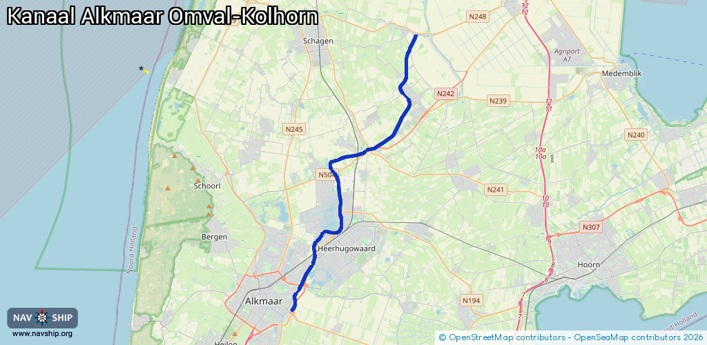
Length:
24.1 km¹
¹River kilometers or bank length recorded in NavShip, including river arms and harbor entrances.
Availability:
Completely recorded
Recent Update: 10.02.2025²
² This date indicates when an adjustment last took place in the course of the body of water
Recorded:
Locks: 1
Harbours / marinas: 2
Bridges: 6
Berths: 0
Slipways: 0
Fuelstations: 0
Route:
Please wait, loading route graphic...
Request waterway overview map with symbol legend here (Link).
Information about data associated with this body of water (9 available):
Data by OpenSeaMap (c) OSM contributors, www.openseamap.org
| # | Kind | Coordinates | Name | Information |
|---|---|---|---|---|
| 1 | Marina | 52.67255,4.817 | 2022-06-19T01:51:03Z | Recreatiehaven Broekhorn |
| 2 | Marina | 52.708,4.81971 | 2022-09-05T06:22:41Z | Watersport Hoogeboom |
| 3 | Bridge | 52.63233,4.78081 | Unknown | Clearance height: 2025-06-09T00:37:51Z m Maximum passage width: 4.93 m Movable bridge (e.g. lifting bridge or drawbridge) fixed |
| 4 | Bridge | 52.64061,4.7867 | Unknown | Clearance height: 2012-12-21T12:26:39Z m Maximum passage width: 5.3 m Movable bridge (e.g. lifting bridge or drawbridge) fixed |
| 5 | Bridge | 52.65729,4.80046 | 12 | Clearance height: 2022-06-06T07:43:00Z m Maximum passage width: 4.70 m Movable bridge (e.g. lifting bridge or drawbridge) opening |
| 6 | Bridge | 52.70899,4.81966 | 7 | Clearance height: 2020-06-24T13:48:22Z m Maximum passage width: 3.6 m Movable bridge (e.g. lifting bridge or drawbridge) fixed |
| 7 | Bridge | 52.78363,4.89528 | Unknown | Clearance height: 2020-06-24T13:48:22Z m Maximum passage width: 4.1 m Movable bridge (e.g. lifting bridge or drawbridge) fixed |
| 8 | Bridge | 52.7903,4.90049 | Unknown | Clearance height: 2012-12-21T12:26:39Z m Maximum passage width: 4.25 m Movable bridge (e.g. lifting bridge or drawbridge) fixed |
| 9 | Lock | 52.70874,4.82006 | Unknown |