Waterway information

Kind:
Inland
Driving areas:
🇳🇱 Netherlands
Length:
9.5 km¹
¹River kilometers or bank length recorded in NavShip, including river arms and harbor entrances.
Availability:
Completely recorded
Recent Update: 13.12.2021²
² This date indicates when an adjustment last took place in the course of the body of water
Recorded:
Locks: 1
Harbours / marinas: 2
Bridges: 6
Berths: 0
Slipways: 0
Fuelstations: 0
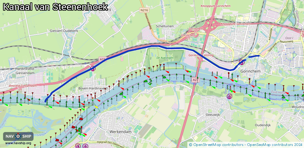
Route:
Please wait, loading route graphic...
Request waterway overview map with symbol legend here (Link).
Information about data associated with this body of water (9 available):
Data by OpenSeaMap (c) OSM contributors, www.openseamap.org
| # | Kind | Coordinates | Name | Information |
|---|---|---|---|---|
| 1 | Marina | 51.83271,4.96884 | 2021-08-22T11:20:51Z | Gorcumse zeil- en roeivereniging |
| 2 | Marina | 51.83046,4.88269 | 2023-02-08T14:49:29Z | W.S.V. 'Huibjesbrug' |
| 3 | Bridge | 51.83511,4.97708 | 9.5 | Clearance height: 2022-06-06T15:00:22Z m Maximum passage width: 4.1 m Movable bridge (e.g. lifting bridge or drawbridge) lifting |
| 4 | Bridge | 51.83184,4.96644 | 10.5 | Clearance height: 2020-09-18T07:27:43Z m Maximum passage width: 1.7 m Movable bridge (e.g. lifting bridge or drawbridge) opening |
| 5 | Bridge | 51.83504,4.94556 | 18.3 | Clearance height: 2013-12-27T17:47:06Z m Maximum passage width: 5.85 m Movable bridge (e.g. lifting bridge or drawbridge) fixed |
| 6 | Bridge | 51.83793,4.92741 | 20.9 | Clearance height: 2013-12-06T13:00:20Z m Maximum passage width: 3.02 m Movable bridge (e.g. lifting bridge or drawbridge) fixed |
| 7 | Bridge | 51.83065,4.88209 | 21 | Clearance height: 2013-12-06T13:00:20Z m Maximum passage width: 3 m Movable bridge (e.g. lifting bridge or drawbridge) fixed |
| 8 | Bridge | 51.82096,4.85807 | 6 | Clearance height: 2013-12-27T17:48:15Z m Maximum passage width: 5.5 m Movable bridge (e.g. lifting bridge or drawbridge) fixed |
| 9 | Lock | 51.82129,4.8583 | Unknown |