Waterway information

Kind:
Lake
Driving areas:
🇳🇱 Netherlands
Length:
14.1 km¹
¹River kilometers or bank length recorded in NavShip, including river arms and harbor entrances.
Availability:
Completely recorded
Recent Update: 22.01.2024²
² This date indicates when an adjustment last took place in the course of the body of water
Recorded:
Locks: 0
Harbours / marinas: 3
Bridges: 3
Berths: 0
Slipways: 0
Fuelstations: 0
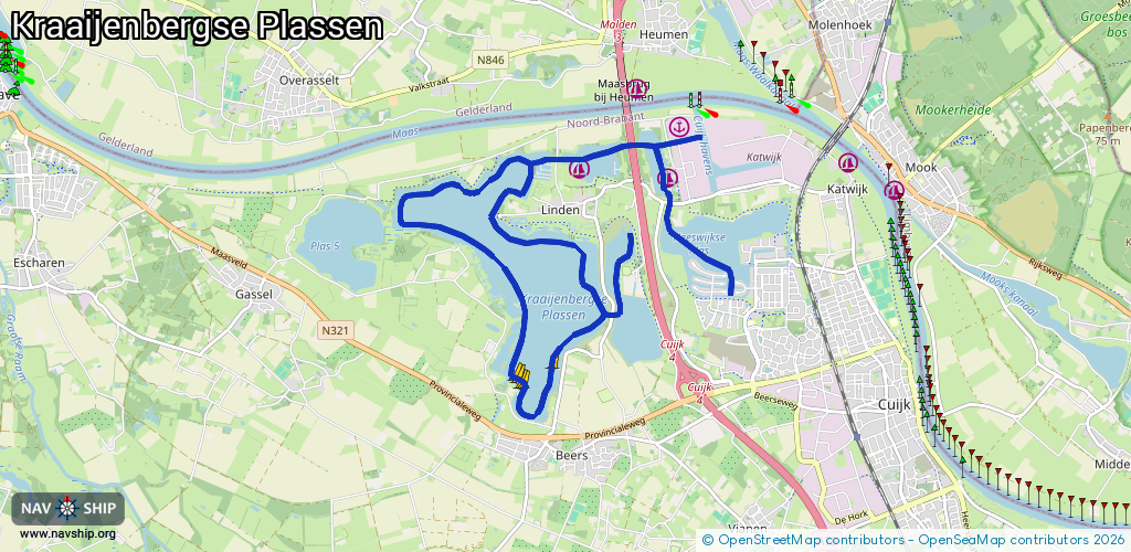
Route:
Please wait, loading route graphic...
Request waterway overview map with symbol legend here (Link).
Information about data associated with this body of water (6 available):
Data by OpenSeaMap (c) OSM contributors, www.openseamap.org
| # | Kind | Coordinates | Name | Information |
|---|---|---|---|---|
| 1 | Marina | 51.7516,5.84529 | 2022-05-04T20:10:46Z | WSV De Kraaijenbergse Plassen |
| 2 | Marina | 51.75238,5.83094 | 2023-11-28T07:50:13Z | Watersportcamping 't Loo |
| 3 | Marina | 51.75694,5.84696 | 2025-06-07T15:43:14Z | Inland Terminal Cuijk [email protected] +31 413 388038 https://www.vanberkellogistics.nl |
| 4 | Bridge | 51.75343,5.8276 | 36 | Clearance height: 2021-10-03T16:29:07Z m Maximum passage width: 7.6 m Movable bridge (e.g. lifting bridge or drawbridge) fixed |
| 5 | Bridge | 51.75471,5.83928 | 20 | Clearance height: 2013-12-30T17:01:06Z m Maximum passage width: 8.7 m Movable bridge (e.g. lifting bridge or drawbridge) fixed |
| 6 | Bridge | 51.75487,5.84469 | 24 | Clearance height: 2018-11-22T20:10:02Z m Maximum passage width: 7.8 m Movable bridge (e.g. lifting bridge or drawbridge) fixed |