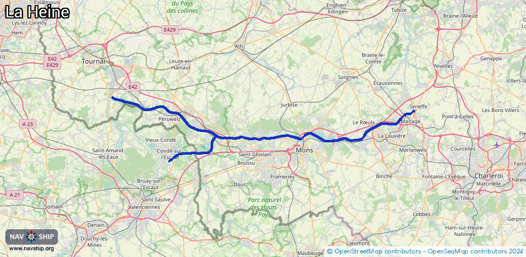
Waterway information

Kind:
Inland
Driving areas:
🇧🇪 Belgium🇫🇷 France
Length:
74.6 km¹
¹River kilometers or bank length recorded in NavShip, including river arms and harbor entrances.
Availability:
Completely recorded
Recent Update: 28.03.2025²
² This date indicates when an adjustment last took place in the course of the body of water
Recorded:
Locks: 7
Harbours / marinas: 5
Bridges: 1
Berths: 0
Slipways: 0
Fuelstations: 0
Route:
Please wait, loading route graphic...
Request waterway overview map with symbol legend here (Link).
Information about data associated with this body of water (13 available):
Data by OpenSeaMap (c) OSM contributors, www.openseamap.org
| # | Kind | Coordinates | Name | Information |
|---|---|---|---|---|
| 1 | Marina | 50.51957,3.60324 | 2025-11-08T08:58:58Z | Port de Plaisance |
| 2 | Marina | 50.51879,3.60854 | 2024-09-22T22:49:41Z | Péruwelz |
| 3 | Marina | 50.46926,3.93804 | 2025-02-21T19:09:53Z | Port de plaisance de Mons |
| 4 | Marina | 50.4702,4.09011 | 2021-01-26T23:46:44Z | Port de plaisance de Thieu |
| 5 | Marina | 50.51719,4.2237 | 2022-05-23T12:42:41Z | |
| 6 | Bridge | 50.47949,3.98105 | 12 | Clearance height: 2020-03-30T11:04:26Z m Maximum passage width: 6.2 m Movable bridge (e.g. lifting bridge or drawbridge) fixed |
| 7 | Lock | 50.54134,3.44777 | Unknown | |
| 8 | Lock | 50.53734,3.47227 | Unknown | |
| 9 | Lock | 50.4791,3.98191 | Unknown | |
| 10 | Lock | 50.47095,4.02581 | Unknown | |
| 11 | Lock | 50.47971,4.11082 | Unknown | |
| 12 | Lock | 50.44989,3.67002 | Unknown | |
| 13 | Lock | 50.47573,3.71078 | Unknown |