Waterway information

Kind:
Inland
Driving areas:
🇺🇸 United States of America
Length:
15.9 km¹
¹River kilometers or bank length recorded in NavShip, including river arms and harbor entrances.
Availability:
Completely recorded
Recent Update: 05.12.2023²
² This date indicates when an adjustment last took place in the course of the body of water
Recorded:
Locks: 0
Harbours / marinas: 8
Bridges: 0
Berths: 0
Slipways: 4
Fuelstations: 0
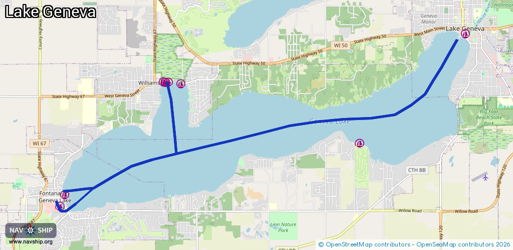
Route:
Please wait, loading route graphic...
Request waterway overview map with symbol legend here (Link).
Information about data associated with this body of water (12 available):
Data by OpenSeaMap (c) OSM contributors, www.openseamap.org
| # | Kind | Coordinates | Name | Information |
|---|---|---|---|---|
| 1 | Marina | 42.57822,-88.53793 | 2023-04-11T20:41:23Z | |
| 2 | Marina | 42.57826,-88.53732 | 2023-04-11T20:41:23Z | |
| 3 | Marina | 42.57829,-88.53627 | 2023-04-11T20:41:23Z | |
| 4 | Marina | 42.57789,-88.53191 | 2021-01-09T22:06:41Z | |
| 5 | Marina | 42.54975,-88.57205 | 2025-08-25T20:23:17Z | |
| 6 | Marina | 42.59035,-88.43438 | 2024-08-16T20:06:43Z | |
| 7 | Marina | 42.56276,-88.47069 | 2022-08-17T20:43:00Z | |
| 8 | Marina | 42.54696,-88.57345 | 2023-04-11T16:56:03Z | Abbey Marina https://abbeymarina.com/ |
| 9 | Slipway | 42.57842,-88.53696 | Unknown | 2014-08-31T03:54:46Z |
| 10 | Slipway | 42.55054,-88.57258 | Unknown | 2025-08-25T20:23:17Z Fontana Boat Ramp |
| 11 | Slipway | 42.54836,-88.57474 | Unknown | 2023-04-11T16:56:03Z |
| 12 | Slipway | 42.54833,-88.57483 | Unknown | 2023-04-11T16:56:03Z |