Waterway information

Kind:
Inland
Driving areas:
🇺🇸 United States of America
Length:
12.8 km¹
¹River kilometers or bank length recorded in NavShip, including river arms and harbor entrances.
Availability:
Completely recorded
Recent Update: 05.12.2023²
² This date indicates when an adjustment last took place in the course of the body of water
Recorded:
Locks: 0
Harbours / marinas: 12
Bridges: 0
Berths: 0
Slipways: 2
Fuelstations: 0
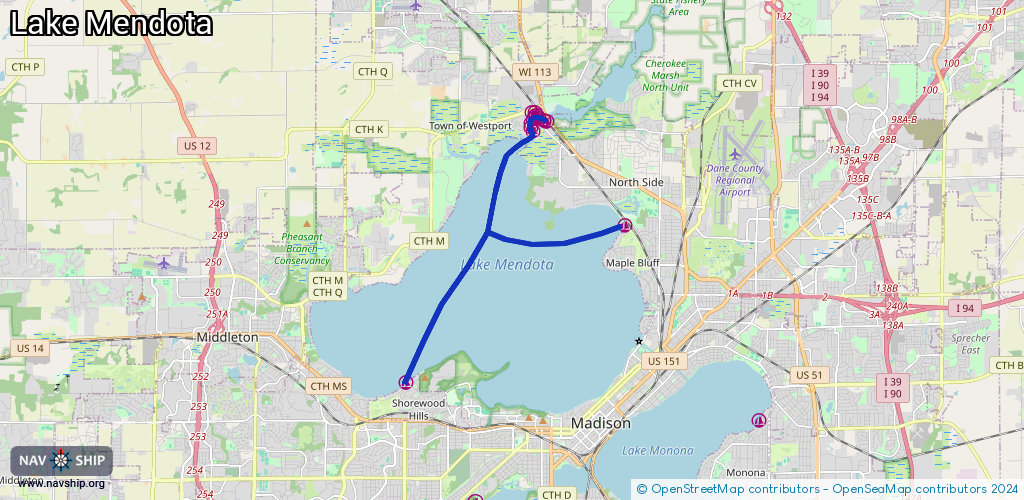
Route:
Please wait, loading route graphic...
Request waterway overview map with symbol legend here (Link).
Information about data associated with this body of water (14 available):
Data by OpenSeaMap (c) OSM contributors, www.openseamap.org
| # | Kind | Coordinates | Name | Information |
|---|---|---|---|---|
| 1 | Marina | 43.08472,-89.4507 | 2022-03-07T01:15:06Z | Shorewood Hills Boathouse |
| 2 | Marina | 43.14781,-89.40681 | 2020-10-08T20:43:10Z | |
| 3 | Marina | 43.14881,-89.40755 | 2020-10-08T20:43:10Z | |
| 4 | Marina | 43.14974,-89.40753 | 2020-10-08T20:43:10Z | |
| 5 | Marina | 43.15246,-89.40732 | 2021-11-23T00:44:45Z | Skipper Buds |
| 6 | Marina | 43.15241,-89.40639 | 2021-11-23T00:44:45Z | Skipper Buds |
| 7 | Marina | 43.15083,-89.40673 | 2020-10-08T20:43:10Z | |
| 8 | Marina | 43.15178,-89.40568 | 2020-10-08T20:43:10Z | Skipper Buds |
| 9 | Marina | 43.15094,-89.40512 | 2020-10-08T20:43:10Z | |
| 10 | Marina | 43.1504,-89.40349 | 2020-10-08T20:43:10Z | |
| 11 | Marina | 43.15015,-89.40249 | 2021-11-23T00:44:45Z | |
| 12 | Marina | 43.12409,-89.37549 | 2021-05-20T23:38:15Z | Maple Bluff Marina |
| 13 | Slipway | 43.15205,-89.40668 | Unknown | 2018-01-12T22:05:47Z |
| 14 | Slipway | 43.15203,-89.4054 | Unknown | 2018-01-12T22:05:47Z |