Waterway information

Kind:
Lake
Driving areas:
🇨🇦 Canada🇺🇸 United States of America
Length:
2431.4 km¹, 563 km official total length
¹River kilometers or bank length recorded in NavShip, including river arms and harbor entrances.
Availability:
Completely recorded
Recent Update: 09.09.2025²
² This date indicates when an adjustment last took place in the course of the body of water
Recorded:
Locks: 0
Harbours / marinas: 30
Bridges: 0
Berths: 2
Slipways: 13
Fuelstations: 7
Useful information:
With an area of around 82,000 square kilometers, Lake Superior is the largest of the five famous Great Lakes in North America and the largest freshwater lake in the world in terms of area.
Around the lake, which is often more reminiscent of a sea, you will find countless sights, spectacular scenery and exciting natural wonders.
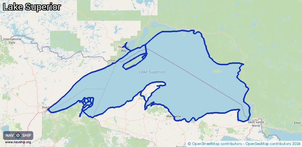
Route:
Please wait, loading route graphic...
Request waterway overview map with symbol legend here (Link).
Information about data associated with this body of water (52 available):
Data by OpenSeaMap (c) OSM contributors, www.openseamap.org
| # | Kind | Coordinates | Name | Information |
|---|
| 1 | Marina | 47.7483,-90.34086 | 2024-10-16T00:12:27Z | Grand Marais Municipal Marina |
| 2 | Marina | 47.27086,-91.27525 | 2020-08-26T19:57:34Z | Silver Bay Marina |
| 3 | Marina | 46.66603,-90.04716 | 2022-07-27T15:09:19Z | Black River Harbor |
| 4 | Marina | 47.45896,-88.14858 | 2025-07-22T02:52:36Z | |
| 5 | Marina | 47.19017,-88.23792 | 2023-12-01T19:32:53Z | |
| 6 | Marina | 46.76037,-84.96488 | 2021-09-14T18:45:59Z | Whitefish Point State Harbor
https://www2.dnr.state.mi.us/Publications/PDFS/harbor_guide/whitefish.htm |
| 7 | Marina | 46.54362,-87.38504 | 2025-07-08T20:37:29Z | Cinder Pond Marina
https://www.marquettemi.gov/departments/community-services/parks-and-recreation/ |
| 8 | Marina | 46.54262,-87.39094 | 2022-12-18T11:50:21Z | Marquette Yacht Club |
| 9 | Marina | 48.37672,-89.2312 | 2024-05-01T00:53:46Z | |
| 10 | Marina | 46.67365,-85.98361 | 2025-09-03T02:20:59Z | Burt Township Marina
+1 906 494 2613
https://www.burttownship.com/recreation/marina/ |
| 11 | Marina | 46.41325,-86.6534 | 2024-11-25T21:05:13Z | Munising Bayshore Marina
+1 906 387 3445
https://cityofmunising.org/marina/ |
| 12 | Marina | 46.78231,-92.09682 | 2021-09-05T15:50:48Z | Minnesota Slip |
| 13 | Marina | 46.77553,-92.09298 | 2023-04-23T11:01:48Z | U.S. Vessel Yard Slip |
| 14 | Marina | 46.77439,-92.09244 | 2025-05-28T10:35:38Z | Lakehead Boat Basin
https://lakeheadboatbasin.com |
| 15 | Marina | 46.77263,-92.09249 | 2025-05-28T10:35:38Z | Harbor Cove Marina
https://parkpointmarinainn.com |
| 16 | Marina | 46.88697,-88.20925 | 2024-03-08T13:45:41Z | Witzs Marina & Campsites
+1 906 524 7795
http://www.witzmarina.com/ |
| 17 | Marina | 46.77719,-88.48366 | 2024-07-07T21:27:04Z | |
| 18 | Marina | 46.85388,-90.78703 | 2025-11-09T11:52:45Z | Buffalo Bay Marina
+1-715-779-3712
http://redcliff-nsn.gov/Tourism/campground.htm |
| 19 | Marina | 48.1479,-88.48585 | 2023-07-28T01:18:28Z | Seaplane, kayak & boat marina |
| 20 | Marina | 47.95682,-84.90319 | 2020-03-11T10:01:03Z | |
| 21 | Marina | 48.14569,-88.48526 | 2023-07-28T01:18:28Z | Rock Harbor Marina |
| 22 | Marina | 47.95627,-89.6899 | 2026-02-07T13:46:16Z | |
| 23 | Marina | 47.38367,-88.01675 | 2023-12-01T18:00:03Z | |
| 24 | Marina | 46.79091,-91.38234 | 2021-06-14T00:10:42Z | Port Wing Marina |
| 25 | Marina | 48.43186,-89.21564 | 2022-08-31T18:21:55Z | |
| 26 | Marina | 48.42572,-89.22084 | 2024-08-21T18:58:45Z | |
| 27 | Marina | 47.93391,-84.83096 | 2019-11-13T02:54:34Z | |
| 28 | Marina | 47.93319,-84.82898 | 2022-02-27T01:25:33Z | Buck’s Marina
[email protected]
+1-705-856-4488
https://www.bucksmarina.com |
| 29 | Marina | 47.9345,-84.82999 | 2019-11-04T19:32:06Z | |
| 30 | Marina | 47.12547,-88.57151 | 2023-01-16T07:10:16Z | Houghton County Marina
+1 906 482 6010
https://www.houghtoncounty.net/directory-marina.php |
| 31 | Slipway | 47.74809,-90.34194 | Unknown | 2025-02-02T13:33:19Z |
| 32 | Slipway | 47.27047,-91.27585 | Unknown | 2012-06-16T17:18:54Z |
| 33 | Slipway | 46.59563,-90.8884 | Unknown | 2021-06-15T18:39:04Z |
| 34 | Slipway | 46.56157,-90.43998 | Unknown | 2021-06-21T01:58:07Z |
| 35 | Slipway | 46.56155,-90.43752 | Unknown | 2021-06-21T01:40:18Z |
| 36 | Slipway | 48.33126,-88.81915 | Unknown | 2024-10-06T20:44:20Z |
| 37 | Slipway | 46.84121,-90.78625 | Unknown | 2012-06-15T15:57:59Z |
| 38 | Slipway | 46.85427,-90.78697 | Unknown | 2020-11-02T17:21:52Z |
| 39 | Slipway | 46.66765,-90.88739 | Unknown | 2022-11-30T00:42:39Z |
| 40 | Slipway | 46.66871,-90.88846 | Unknown | 2025-08-08T22:12:06Z |
| 41 | Slipway | 46.94714,-90.8894 | Unknown | 2024-08-07T00:50:30Z
Little Sand Bay Boat Launch |
| 42 | Slipway | 46.77295,-90.78063 | Unknown | 2022-03-05T15:38:06Z |
| 43 | Slipway | 47.11749,-88.51793 | small_craft_facility | 2024-11-28T13:35:53Z |
| 44 | Berth | 46.77007,-92.09296 | 2026-01-17T02:51:44Z | Duluth Harbor Basin Anchorage Buoy A
anchorage |
| 45 | Berth | 46.77089,-92.09194 | 2023-04-22T13:11:56Z | USCGC Alder
USCGC ALDER's is a buoy tender primarily responsible for Lake Superior and upper Lake Michigan. ALDER often performs ice breaking, law enforcement, and search and rescue, marine environmental protection and port security and safety.
https://www.dvidshub.net/image/1004891/oil-spill-exercise-port-duluth-superior |
| 46 | Fuel station | 46.59482,-90.88741 | 2023-07-27T19:19:23Z | Ashland Marina |
| 47 | Fuel station | 46.4128,-86.65343 | 2024-11-25T21:05:13Z | |
| 48 | Fuel station | 46.84173,-90.78573 | 2025-08-03T06:58:06Z | Roy's Point Marina |
| 49 | Fuel station | 46.80934,-90.81402 | 2025-10-15T23:57:34Z | Bayfield Marina |
| 50 | Fuel station | 47.38189,-88.01985 | 2023-04-15T00:24:42Z | |
| 51 | Fuel station | 46.77277,-90.78165 | 2025-07-24T07:23:11Z | |
| 52 | Fuel station | 47.12524,-88.57122 | 2025-12-03T03:17:00Z | |