Waterway information

Kind:
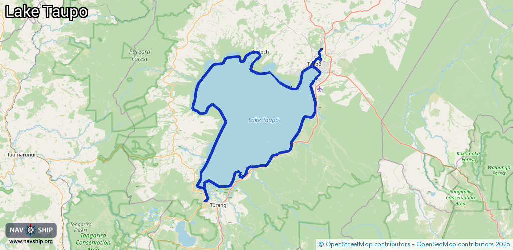
Lake
Driving areas:
🇳🇿 New Zealand🌊 Pacific Ocean
Length:
145.6 km¹
¹River kilometers or bank length recorded in NavShip, including river arms and harbor entrances.
Availability:
Completely recorded
Recent Update: 28.08.2024²
² This date indicates when an adjustment last took place in the course of the body of water
Recorded:
Locks: 0
Harbours / marinas: 4
Bridges: 2
Berths: 4
Slipways: 0
Fuelstations: 0
Route:
Please wait, loading route graphic...
Request waterway overview map with symbol legend here (Link).
Information about data associated with this body of water (10 available):
Data by OpenSeaMap (c) OSM contributors, www.openseamap.org
| # | Kind | Coordinates | Name | Information |
|---|---|---|---|---|
| 1 | Marina | -38.71219,176.02621 | 2020-09-20T07:38:15Z | |
| 2 | Marina | -38.93136,175.87364 | 2021-09-24T08:18:05Z | Motuoapa Marina |
| 3 | Marina | -38.66376,175.9218 | 2023-10-05T02:57:55Z | Kinloch Marina |
| 4 | Marina | -38.95675,175.77019 | 2022-04-03T01:49:23Z | Tokaanu Marina |
| 5 | Bridge | -38.68107,176.06989 | Unknown | Clearance height: 2023-03-03T11:08:34Z m fixed |
| 6 | Bridge | -38.97892,175.77467 | Unknown | Clearance height: 2023-03-03T11:08:34Z m fixed |
| 7 | Berth | -38.71222,176.02786 | 2021-11-08T06:37:24Z | Yacht Moorings small_craft_mooring |
| 8 | Berth | -38.70269,176.03858 | 2021-11-08T06:37:24Z | Yacht Moorings small_craft_mooring |
| 9 | Berth | -38.70956,176.08633 | 2021-11-08T06:37:24Z | Yacht Moorings small_craft_mooring |
| 10 | Berth | -38.66888,175.92146 | 2021-11-08T06:37:24Z | unrestricted |