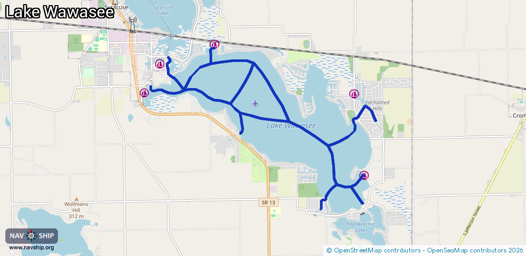
Waterway information

Kind:
Inland
Driving areas:
🇺🇸 United States of America
Length:
19.2 km¹
¹River kilometers or bank length recorded in NavShip, including river arms and harbor entrances.
Availability:
Completely recorded
Recent Update: 04.03.2025²
² This date indicates when an adjustment last took place in the course of the body of water
Recorded:
Locks: 0
Harbours / marinas: 5
Bridges: 0
Berths: 0
Slipways: 7
Fuelstations: 2
Route:
Please wait, loading route graphic...
Request waterway overview map with symbol legend here (Link).
Information about data associated with this body of water (14 available):
Data by OpenSeaMap (c) OSM contributors, www.openseamap.org
| # | Kind | Coordinates | Name | Information |
|---|---|---|---|---|
| 1 | Marina | 41.406,-85.67316 | 2022-06-08T19:15:43Z | Reed's Wawasee Marina |
| 2 | Marina | 41.41362,-85.73741 | 2022-04-13T23:03:02Z | Main Channel Marina |
| 3 | Marina | 41.41822,-85.71972 | 2022-04-11T22:58:38Z | Wawasee Boat Company |
| 4 | Marina | 41.3856,-85.66964 | 2022-04-11T23:21:40Z | Griffith's Wawasee Marina |
| 5 | Marina | 41.40622,-85.7433 | 2022-04-11T23:11:13Z | Wawasee Slip |
| 6 | Slipway | 41.39936,-85.66527 | small_craft_facility | 2022-06-08T19:15:42Z |
| 7 | Slipway | 41.39608,-85.71138 | small_craft_facility | 2022-06-10T12:25:32Z |
| 8 | Slipway | 41.41769,-85.71977 | small_craft_facility | 2022-06-04T18:24:05Z |
| 9 | Slipway | 41.3771,-85.68456 | small_craft_facility | 2022-06-10T12:25:32Z |
| 10 | Slipway | 41.3782,-85.67005 | small_craft_facility | 2022-06-04T18:24:05Z Lake Wawasee Public Launch |
| 11 | Slipway | 41.40616,-85.72908 | small_craft_facility | 2022-06-10T12:25:32Z |
| 12 | Slipway | 41.40818,-85.741 | small_craft_facility | 2022-06-10T12:25:32Z |
| 13 | Fuel station | 41.41395,-85.73535 | 2022-06-04T18:29:49Z | |
| 14 | Fuel station | 41.38574,-85.66988 | 2022-06-04T18:29:49Z |