Waterway information

Kind:
Inland
Driving areas:
🇳🇱 Netherlands
Length:
7.9 km¹
¹River kilometers or bank length recorded in NavShip, including river arms and harbor entrances.
Availability:
Completely recorded
Recent Update: 16.09.2022²
² This date indicates when an adjustment last took place in the course of the body of water
Recorded:
Locks: 0
Harbours / marinas: 2
Bridges: 2
Berths: 0
Slipways: 1
Fuelstations: 0
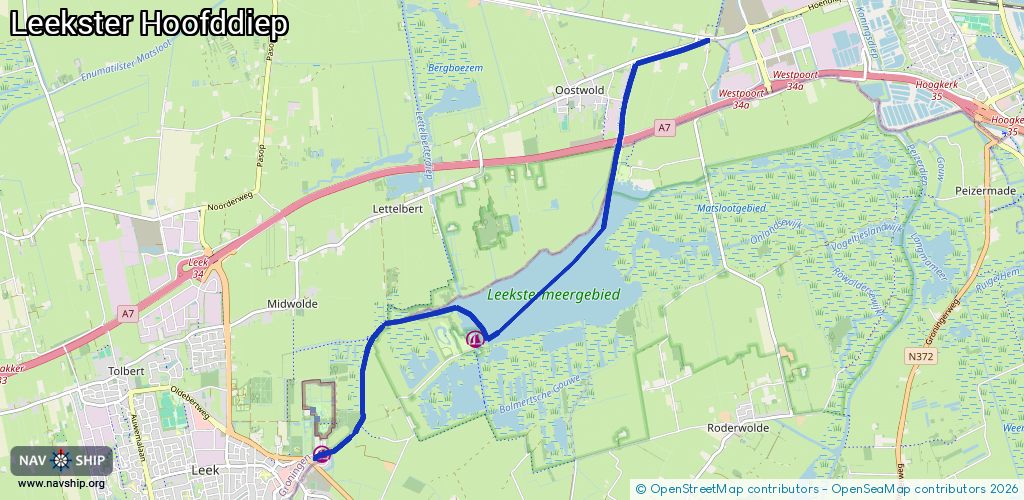
Route:
Please wait, loading route graphic...
Request waterway overview map with symbol legend here (Link).
Information about data associated with this body of water (5 available):
Data by OpenSeaMap (c) OSM contributors, www.openseamap.org
| # | Kind | Coordinates | Name | Information |
|---|---|---|---|---|
| 1 | Marina | 53.17683,6.42345 | 2022-11-28T12:55:49Z | Cnossen |
| 2 | Marina | 53.16475,6.39687 | 2023-08-23T09:17:45Z | Nienoord Haven |
| 3 | Bridge | 53.19701,6.44808 | 10.30 | Clearance height: 2013-02-20T16:47:41Z m Maximum passage width: 3.78 m Movable bridge (e.g. lifting bridge or drawbridge) fixed |
| 4 | Bridge | 53.16796,6.40343 | Unknown | Clearance height: 2013-03-01T12:42:15Z m Maximum passage width: 2.45 m Movable bridge (e.g. lifting bridge or drawbridge) fixed |
| 5 | Slipway | 53.16429,6.39631 | small_craft_facility | 2022-03-02T16:44:49Z |