Waterway information

Kind:
Inland
Driving areas:
🇳🇱 Netherlands
Length:
19.4 km¹
¹River kilometers or bank length recorded in NavShip, including river arms and harbor entrances.
Availability:
Completely recorded
Recent Update: 18.12.2023²
² This date indicates when an adjustment last took place in the course of the body of water
Recorded:
Locks: 1
Harbours / marinas: 2
Bridges: 5
Berths: 0
Slipways: 0
Fuelstations: 0
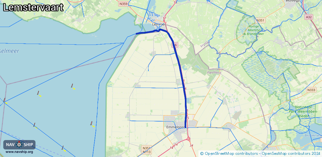
Route:
Please wait, loading route graphic...
Request waterway overview map with symbol legend here (Link).
Information about data associated with this body of water (8 available):
Data by OpenSeaMap (c) OSM contributors, www.openseamap.org
| # | Kind | Coordinates | Name | Information |
|---|---|---|---|---|
| 1 | Marina | 52.72678,5.76627 | 2025-04-17T00:16:58Z | Jachthaven |
| 2 | Marina | 52.83683,5.70756 | 2022-06-06T06:31:29Z | Jachthaven Friese Hoek [email protected] +31 514 568 135 https://www.friesehoek.nl/ |
| 3 | Bridge | 52.71065,5.76731 | 7.46 | Clearance height: 2022-06-06T07:30:47Z m Maximum passage width: 3.5 m Movable bridge (e.g. lifting bridge or drawbridge) opening |
| 4 | Bridge | 52.72548,5.76854 | 22.7 | Clearance height: 2016-04-15T07:05:22Z m Maximum passage width: 6.75 m Movable bridge (e.g. lifting bridge or drawbridge) fixed H65 W75 |
| 5 | Bridge | 52.76499,5.7624 | 8.65 | Clearance height: 2013-02-21T12:51:26Z m Maximum passage width: 7.07 m Movable bridge (e.g. lifting bridge or drawbridge) fixed |
| 6 | Bridge | 52.80951,5.74545 | 8.65 | Clearance height: 2013-02-21T12:51:26Z m Maximum passage width: 6.8 m Movable bridge (e.g. lifting bridge or drawbridge) fixed |
| 7 | Bridge | 52.83774,5.71395 | 7 | Clearance height: 2022-06-06T07:31:16Z m Maximum passage width: 1.68 m Movable bridge (e.g. lifting bridge or drawbridge) opening |
| 8 | Lock | 52.83769,5.71377 | Unknown |