Waterway information

Kind:
Inland
Driving areas:
🇨🇭 Switzerland
Length:
15.2 km¹
¹River kilometers or bank length recorded in NavShip, including river arms and harbor entrances.
Availability:
Completely recorded
Recent Update: 19.02.2025²
² This date indicates when an adjustment last took place in the course of the body of water
Recorded:
Locks: 0
Harbours / marinas: 3
Bridges: 0
Berths: 0
Slipways: 6
Fuelstations: 0
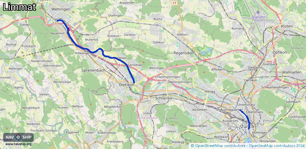
Route:
Please wait, loading route graphic...
Request waterway overview map with symbol legend here (Link).
Information about data associated with this body of water (9 available):
Data by OpenSeaMap (c) OSM contributors, www.openseamap.org
| # | Kind | Coordinates | Name | Information |
|---|---|---|---|---|
| 1 | Marina | 47.45658,8.32389 | 2025-07-12T14:00:48Z | Boots-Steg GB Neuenhof |
| 2 | Marina | 47.45044,8.33528 | 2015-01-06T13:53:44Z | Bootsclub Wettingen http://home.netwings.ch/trenold/bootsclub.htm |
| 3 | Marina | 47.43455,8.35524 | 2026-01-19T00:51:26Z | Fischerverein Stausee |
| 4 | Slipway | 47.38643,8.53315 | Unknown | 2016-04-30T13:30:15Z |
| 5 | Slipway | 47.38674,8.53267 | small_craft_facility | 2017-08-05T05:51:44Z |
| 6 | Slipway | 47.38711,8.53209 | Unknown | 2016-04-30T13:30:15Z |
| 7 | Slipway | 47.39886,8.49368 | Unknown | 2025-02-18T09:33:18Z Auswasserungsstelle Werdinsel |
| 8 | Slipway | 47.39875,8.49261 | Unknown | 2025-02-18T09:33:18Z |
| 9 | Slipway | 47.3988,8.4933 | small_craft_facility | 2025-02-18T09:33:18Z |