Waterway information

Kind:
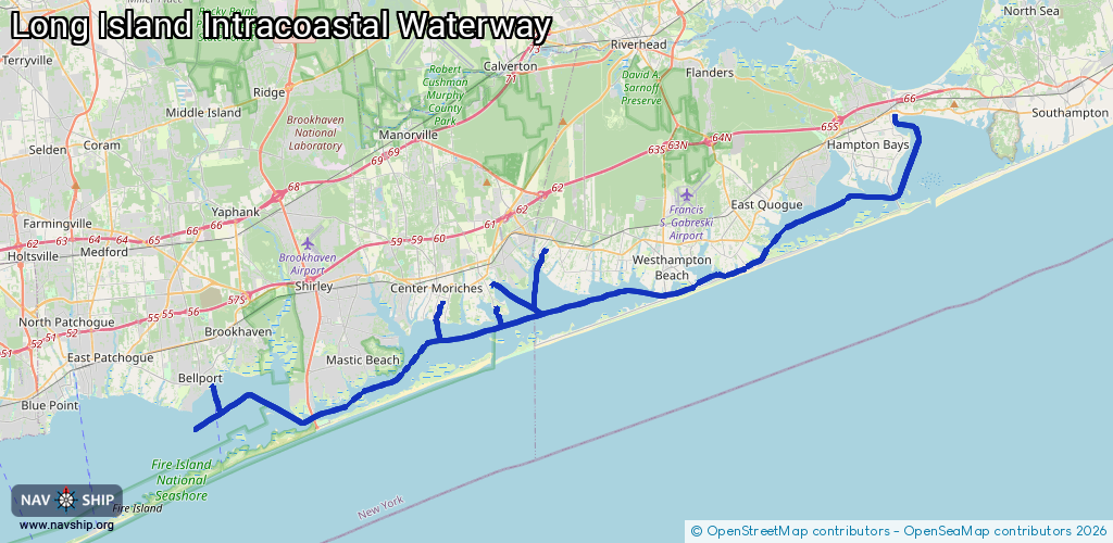
Sea
Driving areas:
🌊 Atlantic Ocean🇺🇸 United States of America
Length:
59 km¹
¹River kilometers or bank length recorded in NavShip, including river arms and harbor entrances.
Availability:
Completely recorded
Recent Update: 13.02.2024²
² This date indicates when an adjustment last took place in the course of the body of water
Recorded:
Locks: 0
Harbours / marinas: 9
Bridges: 0
Berths: 0
Slipways: 0
Fuelstations: 0
Route:
Please wait, loading route graphic...
Request waterway overview map with symbol legend here (Link).
Information about data associated with this body of water (9 available):
Data by OpenSeaMap (c) OSM contributors, www.openseamap.org
| # | Kind | Coordinates | Name | Information |
|---|---|---|---|---|
| 1 | Marina | 40.80225,-72.75576 | 2021-03-14T03:55:42Z | Swezey's Hart Cove Marina |
| 2 | Marina | 40.8162,-72.72263 | 2021-04-03T23:09:00Z | Remsenburg Marina |
| 3 | Marina | 40.81582,-72.72508 | 2021-03-31T22:34:23Z | |
| 4 | Marina | 40.79101,-72.75334 | 2021-03-14T03:55:42Z | Atlantic Cove Marina |
| 5 | Marina | 40.7911,-72.75323 | 2021-03-14T03:55:42Z | Windswept Marina |
| 6 | Marina | 40.75282,-72.93316 | 2021-08-21T21:21:14Z | Bellport Village Marina |
| 7 | Marina | 40.79354,-72.78757 | 2021-11-12T04:08:44Z | Orchard Creek Marina [email protected] +1-631-878-9400 https://www.orchardcreekmarina.com/ |
| 8 | Marina | 40.80353,-72.63718 | 2021-09-27T04:14:25Z | |
| 9 | Marina | 40.8497,-72.50567 | 2022-02-21T20:11:29Z |