Waterway information

Kind:
Inland
Driving areas:
🌊 Atlantic Ocean🇺🇸 United States of America
Length:
28.3 km¹
¹River kilometers or bank length recorded in NavShip, including river arms and harbor entrances.
Availability:
Completely recorded
Recent Update: 22.01.2026²
² This date indicates when an adjustment last took place in the course of the body of water
Recorded:
Locks: 0
Harbours / marinas: 14
Bridges: 0
Berths: 0
Slipways: 0
Fuelstations: 0
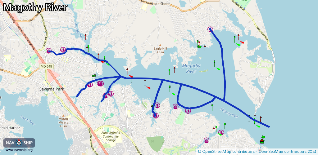
Route:
Please wait, loading route graphic...
Request waterway overview map with symbol legend here (Link).
Information about data associated with this body of water (14 available):
Data by OpenSeaMap (c) OSM contributors, www.openseamap.org
| # | Kind | Coordinates | Name | Information |
|---|---|---|---|---|
| 1 | Marina | 39.05884,-76.48767 | 2022-09-17T03:55:59Z | Ulmstead Estates Dock One |
| 2 | Marina | 39.06333,-76.48695 | 2022-09-16T21:26:56Z | Ulmstead Estates Dock |
| 3 | Marina | 39.09598,-76.4577 | 2021-10-27T14:38:55Z | Hunters Harbour Marina |
| 4 | Marina | 39.0883,-76.47579 | 2026-02-08T20:23:11Z | Broad Creek Marina |
| 5 | Marina | 39.08672,-76.54708 | 2020-05-19T21:33:26Z | |
| 6 | Marina | 39.08728,-76.5391 | 2021-04-18T20:55:32Z | Berrywood Marina 1 Neighborhood Marina with kayak racks and kayak floating loading dock. |
| 7 | Marina | 39.08736,-76.46875 | 2026-01-11T00:22:52Z | North Shore Community Marina |
| 8 | Marina | 39.0609,-76.46991 | 2022-09-17T03:55:59Z | |
| 9 | Marina | 39.06282,-76.4768 | 2022-09-17T03:55:59Z | |
| 10 | Marina | 39.07223,-76.52426 | 2020-05-19T21:33:26Z | |
| 11 | Marina | 39.07269,-76.51874 | 2022-02-08T03:39:18Z | |
| 12 | Marina | 39.07261,-76.51811 | 2022-02-08T03:39:18Z | |
| 13 | Marina | 39.06748,-76.51551 | 2022-02-08T03:39:18Z | |
| 14 | Marina | 39.06826,-76.51257 | 2022-02-08T03:39:18Z | Ferry Point Yacht Club |