Waterway information

Kind:
Lower
Driving areas:
🇳🇱 Netherlands
Length:
15.9 km¹
¹River kilometers or bank length recorded in NavShip, including river arms and harbor entrances.
Availability:
Completely recorded
Recent Update: 08.12.2023²
² This date indicates when an adjustment last took place in the course of the body of water
Recorded:
Locks: 0
Harbours / marinas: 3
Bridges: 10
Berths: 0
Slipways: 0
Fuelstations: 0
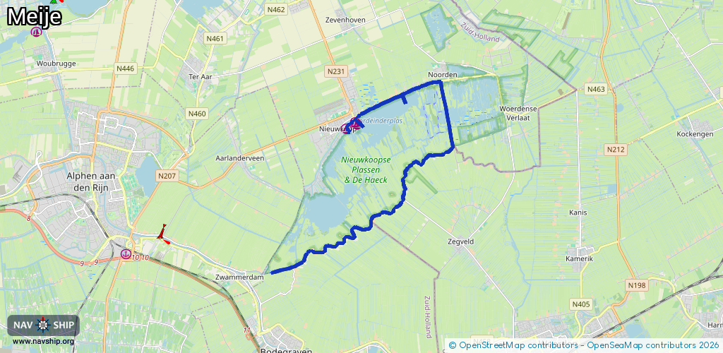
Route:
Please wait, loading route graphic...
Request waterway overview map with symbol legend here (Link).
Information about data associated with this body of water (13 available):
Data by OpenSeaMap (c) OSM contributors, www.openseamap.org
| # | Kind | Coordinates | Name | Information |
|---|---|---|---|---|
| 1 | Marina | 52.15129,4.78526 | 2022-12-12T17:36:56Z | WSV Noord Zuid |
| 2 | Marina | 52.15191,4.7845 | 2023-12-30T22:54:09Z | Plaszicht https://www.tijstermanboten.nl/ |
| 3 | Marina | 52.14996,4.78025 | 2022-12-12T17:25:56Z | Passantenhaven |
| 4 | Bridge | 52.1615,4.81134 | Unknown | Clearance height: 2021-07-12T14:19:35Z m |
| 5 | Bridge | 52.1617,4.81218 | Unknown | Clearance height: 2021-07-12T14:19:35Z m |
| 6 | Bridge | 52.14326,4.82921 | Unknown | Clearance height: 2021-07-12T14:08:21Z m Maximum passage width: 1 m fixed |
| 7 | Bridge | 52.14227,4.82558 | Unknown | Clearance height: 2020-11-03T17:08:01Z m fixed |
| 8 | Bridge | 52.14204,4.82158 | Unknown | Clearance height: 2020-11-03T17:08:01Z m fixed |
| 9 | Bridge | 52.14164,4.81934 | Unknown | Clearance height: 2020-11-03T17:08:01Z m fixed |
| 10 | Bridge | 52.14123,4.81859 | Unknown | Clearance height: 2020-11-03T17:08:01Z m fixed |
| 11 | Bridge | 52.13969,4.817 | Unknown | Clearance height: 2020-11-03T17:08:01Z m fixed |
| 12 | Bridge | 52.13849,4.81002 | Unknown | Clearance height: 2020-11-03T17:08:01Z m fixed |
| 13 | Bridge | 52.10965,4.75613 | Unknown | Clearance height: 2020-10-30T13:11:57Z m Maximum passage width: 1.1 m fixed |