Waterway information

Kind:
Inland
Driving areas:
🌊 Atlantic Ocean🇺🇸 United States of America
Length:
47.6 km¹
¹River kilometers or bank length recorded in NavShip, including river arms and harbor entrances.
Availability:
Completely recorded
Recent Update: 04.04.2025²
² This date indicates when an adjustment last took place in the course of the body of water
Recorded:
Locks: 0
Harbours / marinas: 11
Bridges: 1
Berths: 7
Slipways: 10
Fuelstations: 0
Route:
Please wait, loading route graphic...
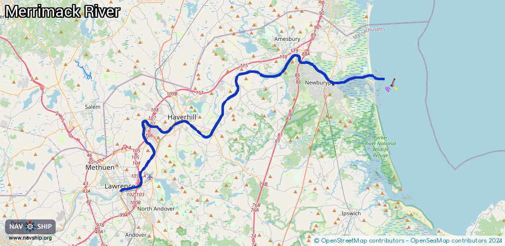
Request waterway overview map with symbol legend here (Link).
Information about data associated with this body of water (29 available):
Data by OpenSeaMap (c) OSM contributors, www.openseamap.org
| # | Kind | Coordinates | Name | Information |
|---|
| 1 | Marina | 42.83268,-70.93277 | 2022-02-26T16:57:54Z | Goodwin Creek Marina
https://goodwincreekmarina.com/ |
| 2 | Marina | 42.83619,-70.92867 | 2022-02-26T17:40:57Z | Marina at Hatter's Point
https://www.marinaathatterspoint.com/ |
| 3 | Marina | 42.84062,-70.92533 | 2022-02-26T17:40:57Z | The Marina at Amebury Point
https://amesburypoint.com/ |
| 4 | Marina | 42.81521,-70.8749 | 2023-11-07T13:02:36Z | McKay’s Wharf
[email protected]
https://newburyportmarinas.com/marinas/windward-yacht-yard/ |
| 5 | Marina | 42.81391,-70.87318 | 2023-11-07T13:02:28Z | McKay’s Wharf
[email protected]
https://newburyportmarinas.com/marinas/windward-yacht-yard/ |
| 6 | Marina | 42.81353,-70.87216 | 2023-11-07T13:02:30Z | Hilton’s Marina
[email protected]
https://newburyportmarinas.com/marinas/hiltons-marina/ |
| 7 | Marina | 42.81295,-70.86963 | 2017-12-05T23:51:53Z | Newburyport City Docks |
| 8 | Marina | 42.81278,-70.86776 | 2018-01-21T22:00:27Z | |
| 9 | Marina | 42.81195,-70.8658 | 2023-11-07T13:02:46Z | Newburyport Harbor Marina
[email protected]
https://newburyportmarinas.com/marinas/newburyport-harbor-marina/ |
| 10 | Marina | 42.811,-70.86195 | 2021-11-27T00:54:32Z | |
| 11 | Marina | 42.80868,-70.84069 | 2018-02-09T03:38:40Z | |
| 12 | Bridge | 42.81569,-70.87296 | Unknown | Clearance height: 2024-12-04T07:10:14Z m
Movable bridge (e.g. lifting bridge or drawbridge)
bascule |
| 13 | Slipway | 42.83249,-70.93276 | Unknown | 2023-02-20T19:25:52Z |
| 14 | Slipway | 42.83245,-70.93292 | small_craft_facility | 2022-02-26T16:57:54Z |
| 15 | Slipway | 42.83999,-70.92579 | Unknown | 2024-11-25T00:05:53Z
Amesbury Public Boat Launch |
| 16 | Slipway | 42.84006,-70.92586 | small_craft_facility | 2024-11-24T23:57:16Z |
| 17 | Slipway | 42.84302,-70.91605 | Unknown | 2023-02-20T19:25:52Z |
| 18 | Slipway | 42.84305,-70.91605 | small_craft_facility | 2022-02-26T13:08:10Z |
| 19 | Slipway | 42.8168,-70.87101 | Unknown | 2014-05-02T22:36:12Z |
| 20 | Slipway | 42.81341,-70.87281 | Unknown | 2018-02-19T17:47:23Z |
| 21 | Slipway | 42.81339,-70.8727 | Unknown | 2018-02-19T17:47:22Z |
| 22 | Slipway | 42.81095,-70.8624 | small_craft_facility | 2018-02-19T17:47:22Z |
| 23 | Berth | 42.82478,-70.88668 | 2018-02-22T19:36:26Z | small_craft_mooring |
| 24 | Berth | 42.82548,-70.88541 | 2018-02-22T19:36:27Z | small_craft_mooring |
| 25 | Berth | 42.82301,-70.87881 | 2018-02-22T19:36:27Z | small_craft_mooring |
| 26 | Berth | 42.82036,-70.87562 | 2018-02-22T19:36:26Z | small_craft_mooring |
| 27 | Berth | 42.81902,-70.8777 | 2018-02-22T19:36:27Z | small_craft_mooring |
| 28 | Berth | 42.81686,-70.87607 | 2018-02-22T19:36:26Z | small_craft_mooring |
| 29 | Berth | 42.81024,-70.8143 | 2018-01-12T15:52:52Z | small_craft_mooring |