Waterway information

Kind:
Inland
Driving areas:
🇮🇹 Italy
Length:
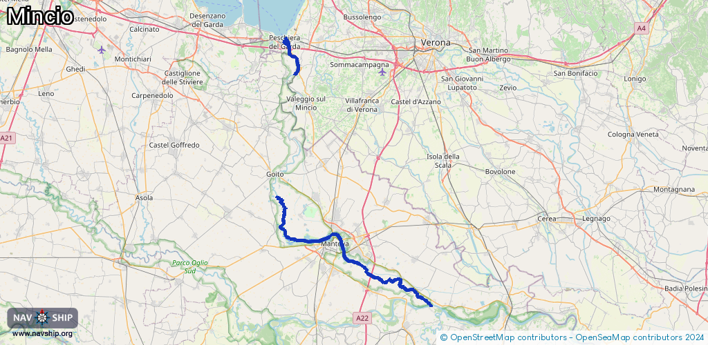
49 km¹
¹River kilometers or bank length recorded in NavShip, including river arms and harbor entrances.
Availability:
Completely recorded
Recent Update: 13.06.2025²
² This date indicates when an adjustment last took place in the course of the body of water
Recorded:
Locks: 0
Harbours / marinas: 7
Bridges: 0
Berths: 0
Slipways: 0
Fuelstations: 1
Route:
Please wait, loading route graphic...
Request waterway overview map with symbol legend here (Link).
Information about data associated with this body of water (8 available):
Data by OpenSeaMap (c) OSM contributors, www.openseamap.org
| # | Kind | Coordinates | Name | Information |
|---|---|---|---|---|
| 1 | Marina | 45.08309,10.95718 | 2025-08-23T06:51:38Z | Porto Turistico Governolo ormeggio e alaggio barche - Bootsliegeplätze und Kranservice |
| 2 | Marina | 45.13151,10.82538 | 2023-09-03T20:50:15Z | La Vallazza |
| 3 | Marina | 45.14551,10.81169 | 2020-12-24T12:49:36Z | Club Motonautico Mantovano |
| 4 | Marina | 45.1796,10.68235 | 2021-07-31T15:02:29Z | Corte Mincio |
| 5 | Marina | 45.1808,10.68133 | 2025-02-18T07:59:49Z | |
| 6 | Marina | 45.44017,10.69051 | 2025-10-03T21:04:21Z | GardaTop Boat tours to Sirmione, Lazise and Peschiera. https://www.gardatop.it/ https://www.gardatop.it/wp-content/uploads/2025/05/garda-top-travel-logo.png |
| 7 | Marina | 45.43971,10.69132 | 2025-10-03T21:04:21Z | Navicharters Boat tours to Sirmione, Lazise and Peschiera del Garda https://www.navicharters.it/ https://www.navicharters.it/xykfifti/2023/11/logo_big_NAVICHARTERS_BLUE.png |
| 8 | Fuel station | 45.43943,10.69245 | 2024-04-15T21:19:34Z |