Waterway information

Kind:
Inland
Driving areas:
🇩🇪 Germany
Length:
4.1 km¹
¹River kilometers or bank length recorded in NavShip, including river arms and harbor entrances.
Availability:
Completely recorded
Recent Update: 29.08.2023²
² This date indicates when an adjustment last took place in the course of the body of water
Recorded:
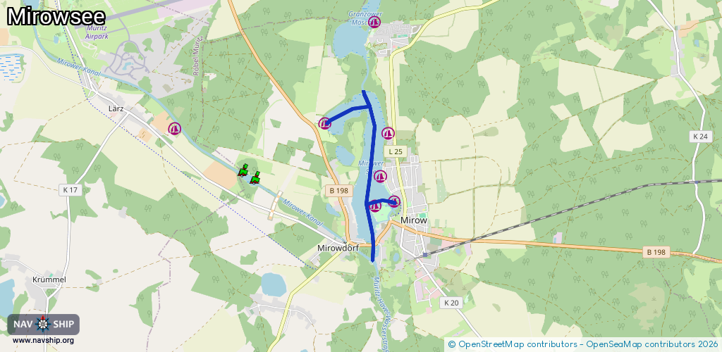
Locks: 0
Harbours / marinas: 5
Bridges: 1
Berths: 0
Slipways: 1
Fuelstations: 1
Route:
Please wait, loading route graphic...
Request waterway overview map with symbol legend here (Link).
Information about data associated with this body of water (8 available):
Data by OpenSeaMap (c) OSM contributors, www.openseamap.org
| # | Kind | Coordinates | Name | Information |
|---|---|---|---|---|
| 1 | Marina | 53.27821,12.81314 | 2024-12-06T23:48:03Z | Segelsportverein Mirow +49 3322 285018 https://www.ssv-mirow.de/ |
| 2 | Marina | 53.27754,12.80851 | 2024-08-21T12:43:57Z | Bootsservice Rick & Rick cee_17_blue [email protected] +49 174 8979683 https://www.bootsservice-rick.de/ |
| 3 | Marina | 53.28184,12.80979 | 2025-01-11T04:04:21Z | Strandrestaurant Mirow [email protected] +49 39833 22019 https://www.strandhotel-mirow.de/ |
| 4 | Marina | 53.28821,12.81148 | 2025-09-25T23:58:41Z | Bootsservice Rick & Rick Benzin, Diesel Mai - September: Täglich von 8.00 - 18:00 Uhr oder telefonisch +49 1748979683 [email protected] +49 1748979683 https://bootsservice-rick.de/UNSERE-HAeFEN/ |
| 5 | Marina | 53.2896,12.79631 | 2024-07-17T01:06:55Z | Freizeitsteg Mirow [email protected] +49 39833 22098 https://kanustation.de/ |
| 6 | Bridge | 53.2719,12.80793 | 20 | Clearance height: 2015-01-14T16:33:51Z m Maximum passage width: 4.2 m Movable bridge (e.g. lifting bridge or drawbridge) fixed |
| 7 | Slipway | 53.28849,12.81092 | small_craft_facility | 2025-09-25T23:58:41Z |
| 8 | Fuel station | 53.28843,12.8109 | 2025-09-25T23:58:41Z |