Waterway information

Kind:
Lower
Driving areas:
🇦🇹 Austria🇨🇿 Czech Republic🇸🇰 Slovakia
Length:
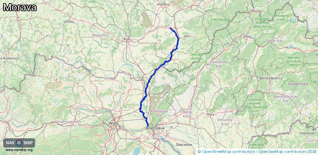
182.6 km¹
¹River kilometers or bank length recorded in NavShip, including river arms and harbor entrances.
Availability:
Completely recorded
Recent Update: 03.04.2025²
² This date indicates when an adjustment last took place in the course of the body of water
Recorded:
Locks: 2
Harbours / marinas: 8
Bridges: 2
Berths: 0
Slipways: 0
Fuelstations: 0
Route:
Please wait, loading route graphic...
Request waterway overview map with symbol legend here (Link).
Information about data associated with this body of water (10 available):
Data by OpenSeaMap (c) OSM contributors, www.openseamap.org
| # | Kind | Coordinates | Name | Information |
|---|---|---|---|---|
| 1 | Marina | 49.15791,17.50859 | 2020-08-10T21:10:42Z | Napajedla - Pahrbek |
| 2 | Marina | 48.888,17.2136 | 2025-10-14T09:06:59Z | Přístav Rohatec – kolonie |
| 3 | Marina | 48.87545,17.19322 | 2025-10-18T14:18:04Z | Přístav Rohatec https://www.rvc.gov.cz/ |
| 4 | Marina | 48.84318,17.14398 | 2025-10-05T19:27:01Z | Přístav U jezu Hodonín |
| 5 | Marina | 48.74466,17.02747 | 2024-08-07T10:46:31Z | Rekreační přístav Tvrdonice |
| 6 | Marina | 48.73552,17.02286 | 2025-03-28T16:11:33Z | Gbely - Adamov https://www.gbely.sk/mesto/navstevnik/zaujimave-lokality/adamovske-jazera-raj-dovolenkarov-24sk.html |
| 7 | Marina | 48.46519,16.86503 | 2023-06-28T18:07:53Z | Prístavisko Gajary |
| 8 | Marina | 48.32151,16.90793 | 2023-06-28T17:52:44Z | Prístav Vysoká pri Morave |
| 9 | Bridge | 48.71661,17.01073 | Unknown | Clearance height: 2025-12-25T21:26:11Z m |
| 10 | Bridge | 48.7173,17.01156 | Unknown | Clearance height: 2026-01-03T13:34:44Z m |
| 10 | Bridge | 48.7173,17.01156 | Unknown | Clearance height: 2026-01-03T13:34:44Z m |
| 10 | Bridge | 48.7173,17.01156 | Unknown | Clearance height: 2026-01-03T13:34:44Z m |