Waterway information

Kind:
Inland
Driving areas:
🇷🇺 Russia
Length:
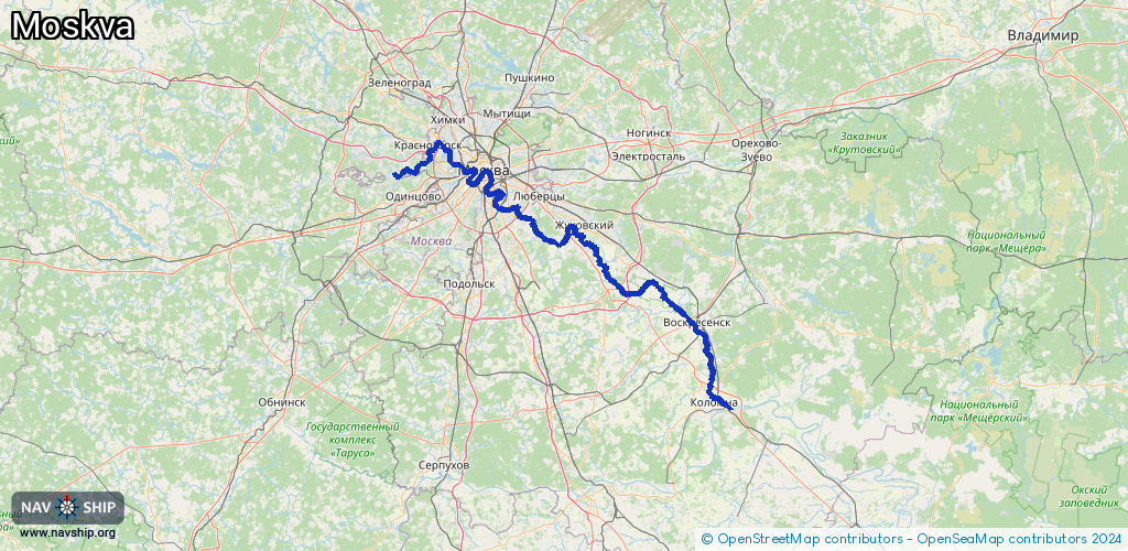
217.5 km¹
¹River kilometers or bank length recorded in NavShip, including river arms and harbor entrances.
Availability:
Completely recorded
Recent Update: 10.04.2025²
² This date indicates when an adjustment last took place in the course of the body of water
Recorded:
Locks: 7
Harbours / marinas: 5
Bridges: 1
Berths: 0
Slipways: 0
Fuelstations: 0
Route:
Please wait, loading route graphic...
Request waterway overview map with symbol legend here (Link).
Information about data associated with this body of water (13 available):
Data by OpenSeaMap (c) OSM contributors, www.openseamap.org
| # | Kind | Coordinates | Name | Information |
|---|---|---|---|---|
| 1 | Marina | 55.64176,37.72513 | 2017-10-17T01:39:03Z | Марьино |
| 2 | Marina | 55.68896,37.69749 | 2023-09-17T22:42:45Z | Яхт-Клуб Ривер Парк Нагатино |
| 3 | Marina | 55.73935,37.60881 | 2026-02-10T17:12:33Z | Московский речной императорский яхт-клуб https://www.irycbg.ru |
| 4 | Marina | 55.8041,37.43872 | 2023-07-25T14:28:08Z | Сила Ветра Mo-Su 09:00-21:00 [email protected] +7 495 1081503 https://silavetra.com/ |
| 5 | Marina | 55.82243,37.38324 | 2025-05-11T13:28:51Z | Яхт-клуб Shore House +7 495 7272577 https://www.sh-crocus.ru/ |
| 6 | Bridge | 55.67379,37.69256 | Unknown | Clearance height: 2023-05-18T11:37:36Z m |
| 7 | Lock | 55.16167,38.75206 | Unknown | |
| 8 | Lock | 55.40959,38.50836 | Unknown | |
| 9 | Lock | 55.48515,38.20276 | Unknown | |
| 10 | Lock | 55.55548,37.93144 | Unknown | |
| 11 | Lock | 55.61744,37.82121 | Unknown | |
| 12 | Lock | 55.67456,37.69575 | Unknown | |
| 13 | Lock | 55.76722,37.47316 | Unknown |