Waterway information

Kind:
Inland
Driving areas:
🇵🇱 Poland
Length:
48 km¹
¹River kilometers or bank length recorded in NavShip, including river arms and harbor entrances.
Availability:
Completely recorded
Recent Update: 08.01.2025²
² This date indicates when an adjustment last took place in the course of the body of water
Recorded:
Locks: 2
Harbours / marinas: 4
Bridges: 3
Berths: 0
Slipways: 2
Fuelstations: 0
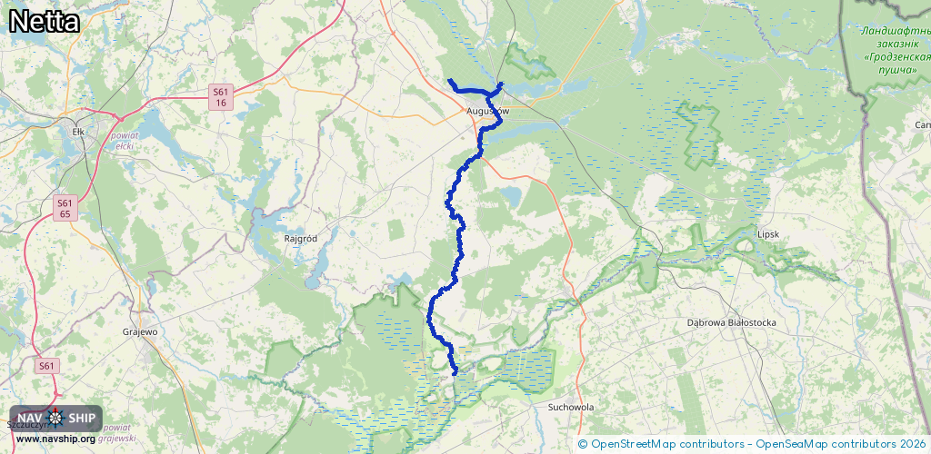
Route:
Please wait, loading route graphic...
Request waterway overview map with symbol legend here (Link).
Information about data associated with this body of water (9 available):
Data by OpenSeaMap (c) OSM contributors, www.openseamap.org
| # | Kind | Coordinates | Name | Information |
|---|---|---|---|---|
| 1 | Marina | 53.86115,22.93117 | 2025-01-02T05:07:51Z | |
| 2 | Marina | 53.8516,22.97908 | 2017-01-08T20:32:27Z | |
| 3 | Marina | 53.84451,22.99515 | 2021-08-15T19:05:37Z | |
| 4 | Marina | 53.8448,22.9919 | 2021-08-14T10:54:24Z | |
| 5 | Bridge | 53.84765,22.98548 | Unknown | Clearance height: 2023-12-27T12:55:06Z m channel_two_way |
| 6 | Bridge | 53.84761,22.98539 | Unknown | Clearance height: 2023-12-27T12:55:06Z m no_passage_left |
| 7 | Bridge | 53.84768,22.98557 | Unknown | Clearance height: 2023-12-27T12:55:06Z m no_passage_right |
| 8 | Slipway | 53.85089,22.97876 | small_craft_facility | 2017-03-03T15:04:10Z |
| 9 | Slipway | 53.84439,22.99395 | shoreline_construction | 2021-10-12T19:25:40Z |
| 9 | Slipway | 53.84439,22.99395 | shoreline_construction | 2021-10-12T19:25:40Z |
| 9 | Slipway | 53.84439,22.99395 | shoreline_construction | 2021-10-12T19:25:40Z |