Waterway information

Kind:
Inland
Driving areas:
🇨🇦 Canada🇺🇸 United States of America
Length:
74.6 km¹
¹River kilometers or bank length recorded in NavShip, including river arms and harbor entrances.
Availability:
Completely recorded
Recent Update: 04.03.2025²
² This date indicates when an adjustment last took place in the course of the body of water
Recorded:
Locks: 0
Harbours / marinas: 21
Bridges: 0
Berths: 0
Slipways: 4
Fuelstations: 3
Route:
Please wait, loading route graphic...
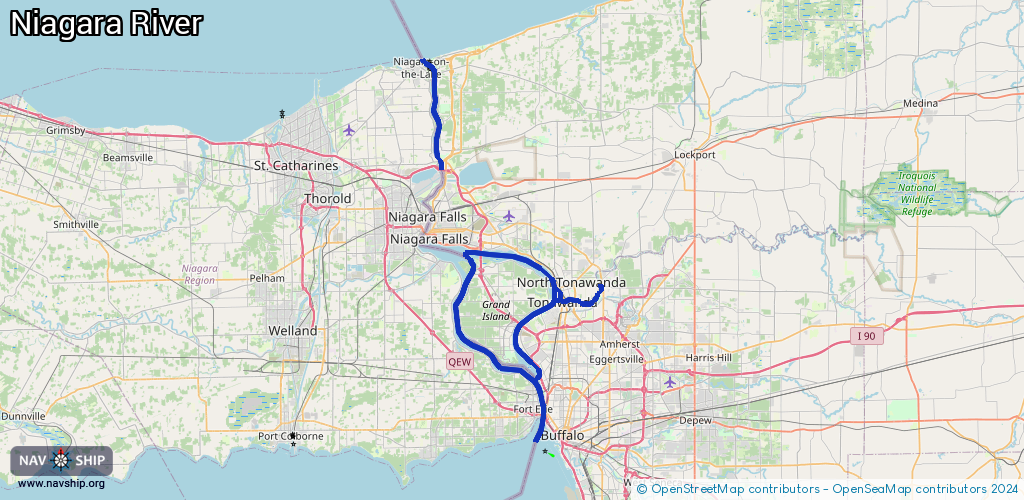
Request waterway overview map with symbol legend here (Link).
Information about data associated with this body of water (28 available):
Data by OpenSeaMap (c) OSM contributors, www.openseamap.org
| # | Kind | Coordinates | Name | Information |
|---|
| 1 | Marina | 43.02428,-79.01127 | 2025-01-21T18:24:25Z | Big Six Mile Creek Marina
+1 716-773-3270
https://parks.ny.gov/parks/bigsixmile/ |
| 2 | Marina | 43.02255,-79.01105 | 2024-02-11T04:47:54Z | Big Six Mile Creek Marina |
| 3 | Marina | 42.95895,-78.95462 | 2015-10-06T09:23:18Z | Beaver Island State Park Marina |
| 4 | Marina | 43.25559,-79.06244 | 2023-02-17T20:33:55Z | Niagara-on-the-Lake Sailing Club |
| 5 | Marina | 43.25184,-79.05093 | 2022-07-13T11:33:56Z | Youngstown Yacht Club North Dock |
| 6 | Marina | 43.16686,-79.05302 | 2024-08-14T07:31:22Z | Whirlpool JetBoat |
| 7 | Marina | 42.9736,-78.93461 | 2015-10-06T09:05:09Z | Mid-River Marina |
| 8 | Marina | 42.97413,-78.93524 | 2025-10-12T14:19:22Z | |
| 9 | Marina | 42.97145,-78.94433 | 2015-10-06T09:05:09Z | Blue Water Marine |
| 10 | Marina | 42.98748,-78.94775 | 2015-10-06T08:51:17Z | River Port Inn Marina |
| 11 | Marina | 43.02392,-78.89689 | 2015-10-06T08:22:45Z | River Oaks Marina |
| 12 | Marina | 43.02411,-78.89536 | 2023-01-25T20:19:29Z | |
| 13 | Marina | 43.04006,-78.8998 | 2021-03-21T20:21:04Z | Niagara Sailing Club |
| 14 | Marina | 43.04751,-78.89171 | 2020-05-13T18:22:01Z | |
| 15 | Marina | 43.0473,-78.89172 | 2022-08-18T14:28:49Z | North Tonawanda Marina |
| 16 | Marina | 43.06176,-78.96035 | 2015-10-03T18:08:36Z | Sandy Beach Yacht Club Incorporation |
| 17 | Marina | 43.07317,-78.98034 | 2015-10-03T18:08:41Z | Tradewinds Marina |
| 18 | Marina | 43.03377,-78.88516 | 2015-10-06T08:22:47Z | East Pier Marina |
| 19 | Marina | 43.03202,-78.88226 | 2015-10-06T08:22:46Z | Bow & Stern Marina |
| 20 | Marina | 43.02681,-78.88088 | 2015-10-06T08:22:46Z | Winfield Marine |
| 21 | Marina | 43.02469,-78.88384 | 2015-10-06T08:22:45Z | Placid II Marina |
| 22 | Slipway | 42.96995,-78.94407 | small_craft_facility | 2015-10-06T09:05:09Z |
| 23 | Slipway | 43.00965,-78.91022 | small_craft_facility | 2021-05-02T20:58:04Z |
| 24 | Slipway | 43.07333,-78.97605 | small_craft_facility | 2015-10-03T17:03:04Z |
| 25 | Slipway | 43.02164,-78.85484 | small_craft_facility | 2013-05-12T15:22:13Z |
| 26 | Fuel station | 43.25535,-79.06185 | 2024-08-14T07:31:22Z | |
| 27 | Fuel station | 43.25532,-79.06173 | 2024-08-14T07:31:22Z | |
| 28 | Fuel station | 42.99688,-78.93521 | 2024-07-13T22:25:09Z | Collins Gas Dock |