Waterway information

Kind:
Inland
Driving areas:
🇳🇱 Netherlands
Length:
3.2 km¹
¹River kilometers or bank length recorded in NavShip, including river arms and harbor entrances.
Availability:
Completely recorded
Recent Update: 08.08.2023²
² This date indicates when an adjustment last took place in the course of the body of water
Recorded:
Locks: 1
Harbours / marinas: 1
Bridges: 6
Berths: 0
Slipways: 0
Fuelstations: 0
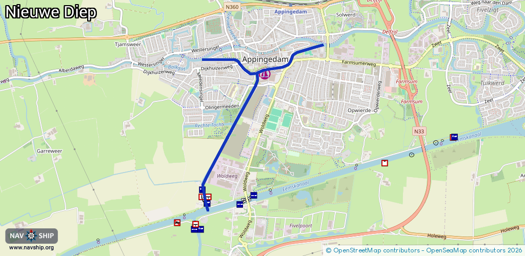
Route:
Please wait, loading route graphic...
Request waterway overview map with symbol legend here (Link).
Information about data associated with this body of water (8 available):
Data by OpenSeaMap (c) OSM contributors, www.openseamap.org
| # | Kind | Coordinates | Name | Information |
|---|---|---|---|---|
| 1 | Marina | 53.31892,6.85759 | 2023-05-30T17:10:32Z | Stadshaven Appingedam +31 596 682 881 https://www.jachthavenappingedam.nl |
| 2 | Bridge | 53.32008,6.86191 | 8.88 | Clearance height: 2013-02-20T13:29:05Z m Maximum passage width: 1.20 m Movable bridge (e.g. lifting bridge or drawbridge) opening |
| 3 | Bridge | 53.31937,6.85812 | 7 | Clearance height: 2013-02-20T13:29:04Z m Maximum passage width: 1.40 m Movable bridge (e.g. lifting bridge or drawbridge) opening |
| 4 | Bridge | 53.31772,6.85611 | 8.7 | Clearance height: 2020-06-09T14:01:42Z m Maximum passage width: 1.4 m Movable bridge (e.g. lifting bridge or drawbridge) opening |
| 5 | Bridge | 53.3138,6.85057 | Unknown | Clearance height: 2020-06-09T14:01:42Z m Movable bridge (e.g. lifting bridge or drawbridge) fixed |
| 6 | Bridge | 53.30634,6.84762 | 8.64 | Clearance height: 2022-06-05T13:15:41Z m Maximum passage width: 1.10 m Movable bridge (e.g. lifting bridge or drawbridge) opening |
| 7 | Bridge | 53.31992,6.85338 | 7.96 | Clearance height: 2022-06-05T13:15:09Z m Maximum passage width: 1.08 m Movable bridge (e.g. lifting bridge or drawbridge) opening |
| 8 | Lock | 53.30677,6.84746 | Unknown |