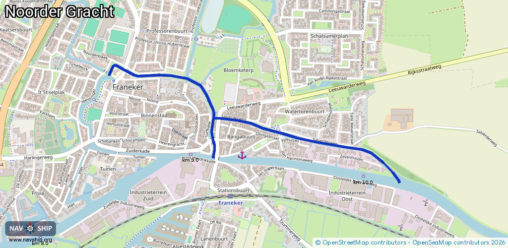
Waterway information

Kind:
Inland
Driving areas:
🇳🇱 Netherlands
Length:
2.2 km¹
¹River kilometers or bank length recorded in NavShip, including river arms and harbor entrances.
Availability:
Completely recorded
Recent Update: 04.03.2025²
² This date indicates when an adjustment last took place in the course of the body of water
Recorded:
Locks: 0
Harbours / marinas: 0
Bridges: 15
Berths: 0
Slipways: 0
Fuelstations: 0
Route:
Please wait, loading route graphic...
Request waterway overview map with symbol legend here (Link).
Information about data associated with this body of water (15 available):
Data by OpenSeaMap (c) OSM contributors, www.openseamap.org
| # | Kind | Coordinates | Name | Information |
|---|---|---|---|---|
| 1 | Bridge | 53.1853,5.54834 | 7 | Clearance height: 2025-12-01T15:09:21Z m Maximum passage width: 2.50 m fixed |
| 2 | Bridge | 53.18578,5.54691 | Unknown | Clearance height: 2025-11-30T16:03:45Z m fixed |
| 3 | Bridge | 53.1867,5.54841 | 5.45 | Clearance height: 2025-12-01T15:09:21Z m Maximum passage width: 2.50 m fixed |
| 4 | Bridge | 53.1866,5.54699 | Unknown | Clearance height: 2025-11-30T16:03:45Z m fixed |
| 5 | Bridge | 53.18719,5.5461 | Unknown | Clearance height: 2025-11-30T16:03:45Z m fixed |
| 6 | Bridge | 53.18733,5.54615 | Unknown | Clearance height: 2025-11-30T16:03:45Z m fixed |
| 7 | Bridge | 53.18824,5.54733 | Unknown | Clearance height: 2025-12-01T11:23:34Z m fixed |
| 8 | Bridge | 53.18829,5.54601 | Unknown | Clearance height: 2025-11-30T16:03:45Z m fixed |
| 9 | Bridge | 53.1877,5.54581 | Unknown | Clearance height: 2025-11-30T16:03:45Z m fixed |
| 10 | Bridge | 53.18727,5.54474 | Unknown | Clearance height: 2025-11-30T16:03:45Z m fixed |
| 11 | Bridge | 53.18867,5.54365 | 6.3 | Clearance height: 2025-12-01T15:09:21Z m Maximum passage width: 1.90 m Movable bridge (e.g. lifting bridge or drawbridge) fixed |
| 12 | Bridge | 53.18753,5.54133 | Unknown | Clearance height: 2025-11-30T16:03:45Z m fixed |
| 13 | Bridge | 53.18738,5.54241 | Unknown | Clearance height: 2025-11-30T16:03:45Z m fixed |
| 14 | Bridge | 53.18565,5.55432 | 5.10 | Clearance height: 2025-12-01T11:23:34Z m Maximum passage width: 2.50 m fixed |
| 15 | Bridge | 53.18645,5.54885 | 4.91 | Clearance height: 2025-12-01T11:23:34Z m Maximum passage width: 2.50 m fixed |