Waterway information

Kind:
Inland
Driving areas:
🇩🇪 Germany
Length:
35.4 km¹
¹River kilometers or bank length recorded in NavShip, including river arms and harbor entrances.
Availability:
Completely recorded
Recent Update: 10.04.2025²
² This date indicates when an adjustment last took place in the course of the body of water
Recorded:
Locks: 0
Harbours / marinas: 5
Bridges: 3
Berths: 0
Slipways: 1
Fuelstations: 0
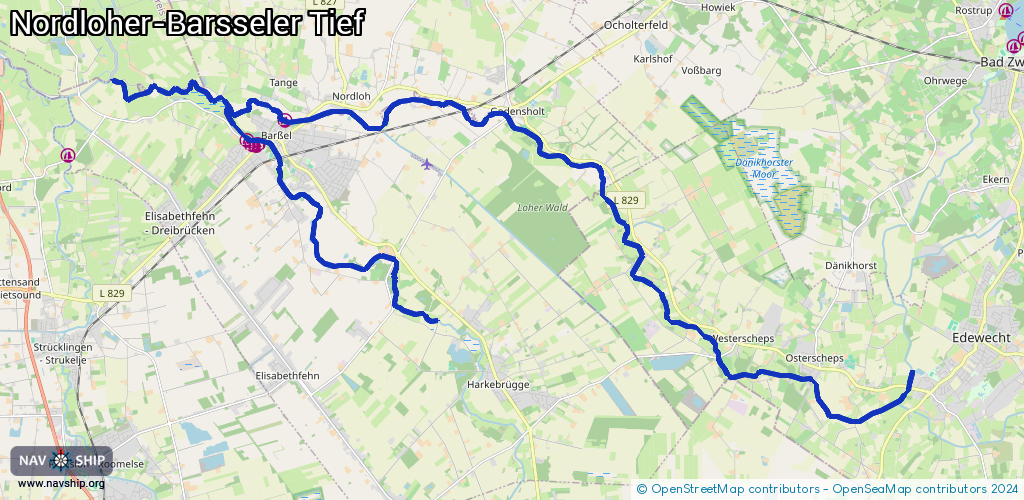
Route:
Please wait, loading route graphic...
Request waterway overview map with symbol legend here (Link).
Information about data associated with this body of water (9 available):
Data by OpenSeaMap (c) OSM contributors, www.openseamap.org
| # | Kind | Coordinates | Name | Information |
|---|---|---|---|---|
| 1 | Marina | 53.1681,7.73693 | 2023-05-11T09:12:46Z | Bootsclub Barßel https://www.bootsclubbarssel.de/ |
| 2 | Marina | 53.16777,7.73658 | 2023-03-05T11:48:16Z | WSC Poseidon Barßel e.V. |
| 3 | Marina | 53.16793,7.73526 | 2023-11-04T13:31:53Z | Sportboothafen Barßel http://poseidon-barssel.de/html/body_infos_fur_den_barsseler-hafen.html +49 174 5459734 http://poseidon-barssel.de/html/body_infos_fur_den_barsseler-hafen.html +49 |
| 4 | Marina | 53.16886,7.73336 | 2023-05-11T09:12:46Z | Wassersportclub Soeste Barßel [email protected] +49 4492 1785 http://www.wsc-soeste.de |
| 5 | Marina | 53.17297,7.74639 | 2023-05-11T09:07:24Z | Wassersportverein Neptun Barßel |
| 6 | Bridge | 53.16879,7.7393 | Unknown | Clearance height: 2014-04-30T10:56:51Z m fixed |
| 7 | Bridge | 53.169,7.73542 | Unknown | Clearance height: 2014-05-03T17:38:34Z m fixed |
| 8 | Bridge | 53.17327,7.75365 | Unknown | Clearance height: 2014-04-30T10:56:47Z m fixed |
| 9 | Slipway | 53.16907,7.73228 | small_craft_facility | 2026-02-21T16:25:27Z |