Waterway information

Kind:
Inland
Driving areas:
🇩🇪 Germany
Length:
13.6 km¹
¹River kilometers or bank length recorded in NavShip, including river arms and harbor entrances.
Availability:
Completely recorded
Recent Update: 31.03.2025²
² This date indicates when an adjustment last took place in the course of the body of water
Recorded:
Locks: 0
Harbours / marinas: 6
Bridges: 1
Berths: 0
Slipways: 3
Fuelstations: 0
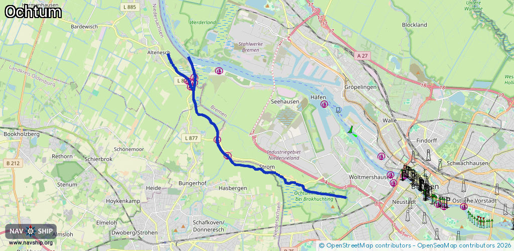
Route:
Please wait, loading route graphic...
Request waterway overview map with symbol legend here (Link).
Information about data associated with this body of water (10 available):
Data by OpenSeaMap (c) OSM contributors, www.openseamap.org
| # | Kind | Coordinates | Name | Information |
|---|---|---|---|---|
| 1 | Marina | 53.08832,8.67215 | 2023-05-10T11:09:13Z | Wassersportverein Niedervieland (WVN) https://www.wvn-bremen.de/ |
| 2 | Marina | 53.0949,8.66516 | 2021-05-06T16:02:26Z | Wassersportverein Strom (WVSt) Spille https://www.wvst.de/ |
| 3 | Marina | 53.11843,8.64918 | 2021-05-06T16:17:07Z | Wassersportverein Strom (WVSt) https://www.wvst.de/ |
| 4 | Marina | 53.1204,8.64946 | 2019-03-10T16:20:58Z | Delmenhorster Wassersport Verein (DWV) [email protected] +49 4221 18271 https://dwv-ochtum.de/ |
| 5 | Marina | 53.11912,8.64487 | 2021-05-06T16:21:01Z | Wassersportverein Strom (WVSt) https://www.wvst.de/ |
| 6 | Marina | 53.11666,8.64694 | 2021-05-06T16:24:09Z | Segel-Club Ochtum (SCO) http://www.scochtum.de/index.html |
| 7 | Bridge | 53.07205,8.74546 | Unknown | Clearance height: 2013-02-07T17:26:44Z m fixed |
| 8 | Slipway | 53.08849,8.67261 | small_craft_facility | 2019-08-24T09:42:22Z |
| 9 | Slipway | 53.11678,8.64641 | small_craft_facility | 2014-01-21T00:21:09Z |
| 10 | Slipway | 53.11554,8.64749 | small_craft_facility | 2018-07-13T09:43:40Z |