Waterway information

Kind:
Inland
Driving areas:
🇺🇸 United States of America
Length:
1559.6 km¹, 1579 km official total length
¹River kilometers or bank length recorded in NavShip, including river arms and harbor entrances.
Availability:
Completely recorded
Recent Update: 11.02.2026²
² This date indicates when an adjustment last took place in the course of the body of water
Recorded:
Locks: 18
Harbours / marinas: 21
Bridges: 0
Berths: 5
Slipways: 2
Fuelstations: 0
Useful information:
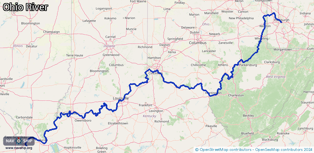
The Ohio River is without doubt a remarkable river in North America. A special feature is that every single one of its 1579 kilometers is navigable.
Of course, this only works because the source is a confluence of existing rivers. This is exactly how the Ohio River is formed in Pittsburgh in the US state of Pennsylvania. The Allegheny and the Monongahela flow into each other there.
Another special feature is the mouth of the Ohio. It does not flow into an ocean, but ends in one of the most famous and longest rivers in the world. Near the city of Cairo in the state of Illinois, the Ohio River flows into the Upper Mississippi and thus becomes an important part of its river system.
The Ohio used to be a comparatively shallow river. It was only a few meters deep in places, making it impassable for larger ships. Gradually, from the end of the 19th century, the Ohio River was systematically deepened and dammed. This finally made the entire length of the river navigable for inland shipping.
Route:
Please wait, loading route graphic...
Request waterway overview map with symbol legend here (Link).
Information about data associated with this body of water (46 available):
Data by OpenSeaMap (c) OSM contributors, www.openseamap.org
| # | Kind | Coordinates | Name | Information |
|---|
| 1 | Marina | 40.51605,-80.13005 | 2024-08-20T13:32:37Z | Midway Marine Marina
http://www.midwaymarinepgh.com/ |
| 2 | Marina | 40.53362,-80.18529 | 2024-08-14T16:16:38Z | Chestnut Street Motorized Boat Dock
https://www.sewickleyborough.org/316/Public-Transportation |
| 3 | Marina | 40.53534,-80.18848 | 2024-08-14T16:16:38Z | Walnut Street Non-Motorized Boat Dock
https://www.sewickleyborough.org/316/Public-Transportation |
| 4 | Marina | 40.45003,-80.60622 | 2024-08-23T06:57:51Z | Skipper Haven Yacht Club |
| 5 | Marina | 40.37942,-80.61621 | 2021-03-18T13:49:39Z | City of Steubenville Marina |
| 6 | Marina | 40.09776,-80.7132 | 2023-09-17T05:28:28Z | Martin's Ferry Yacht Club |
| 7 | Marina | 39.26519,-81.6978 | 2023-05-16T19:18:59Z | stream access |
| 8 | Marina | 38.80486,-82.21471 | 2021-03-22T14:38:03Z | |
| 9 | Marina | 38.61447,-82.85058 | 2023-09-18T14:19:00Z | Holiday Point Marina |
| 10 | Marina | 38.73006,-83.00653 | 2022-04-21T20:27:35Z | |
| 11 | Marina | 38.77187,-83.91424 | 2024-01-11T13:56:24Z | |
| 12 | Marina | 38.94161,-84.27459 | 2024-10-16T01:40:02Z | Little Indian Creek Boat Club |
| 13 | Marina | 38.94755,-84.28183 | 2024-10-08T23:04:12Z | New Richmond Harbor |
| 14 | Marina | 39.08421,-84.43753 | 2025-10-22T18:00:46Z | Aquaramp Marina |
| 15 | Marina | 39.08627,-84.43007 | 2025-11-23T02:44:28Z | Four Seasons Marina |
| 16 | Marina | 39.09253,-84.43037 | 2025-11-23T01:08:24Z | Rivertown Marina |
| 17 | Marina | 39.117,-84.45944 | 2026-01-28T01:50:03Z | Manhattan Harbor |
| 18 | Marina | 38.77145,-84.93111 | 2020-12-04T22:55:45Z | Smugglers Cove
+1 859-567-7601 |
| 19 | Marina | 38.32982,-85.64115 | 2024-12-04T02:24:15Z | Harrods Creek Marina |
| 20 | Marina | 37.92506,-87.62803 | 2024-05-05T03:21:51Z | Nu Plaza Yacht Club
+1-812-423-0712
https://nuplazayachtclub.com |
| 21 | Marina | 37.92154,-87.62806 | 2024-11-20T18:43:22Z | Dogtown Boat Ramp |
| 22 | Slipway | 38.27966,-85.7877 | small_craft_facility | 2025-03-08T12:50:36Z |
| 23 | Slipway | 37.92154,-87.62806 | harbour | 2024-11-20T18:43:22Z
Dogtown Boat Ramp |
| 24 | Berth | 40.51062,-80.11369 | 2025-03-02T17:22:07Z | Towboat Evanick |
| 25 | Berth | 40.52998,-80.17369 | 2025-02-18T14:51:26Z | USCGC Osage
River buoy tenders deploy buoys and day boards to mark river channels, ensuring the safe and efficient flow of river commerce. These cutters push barges equipped with cranes for lifting buoys, these barges are integral to the cutter’s mission. |
| 26 | Berth | 38.25918,-85.75566 | 2022-11-27T20:15:20Z | Belle of Louisville |
| 27 | Berth | 38.2798,-85.78552 | 2025-03-09T22:33:00Z | Towboat JC Thomas |
| 28 | Berth | 37.1852,-89.06419 | 2025-09-13T02:35:10Z | M/V Jackie Lee Anderson |
| 29 | Lock | 40.50436,-80.08838 | Unknown | |
| 30 | Lock | 40.54876,-80.206 | Unknown | |
| 31 | Lock | 40.64825,-80.38523 | Unknown | |
| 32 | Lock | 40.52617,-80.62753 | Unknown | |
| 33 | Lock | 40.14813,-80.70099 | Unknown | |
| 34 | Lock | 39.6652,-80.86555 | Unknown | |
| 35 | Lock | 39.36031,-81.32198 | Unknown | |
| 36 | Lock | 39.11742,-81.74317 | Unknown | |
| 37 | Lock | 38.91769,-81.91147 | Unknown | |
| 38 | Lock | 38.68216,-82.18427 | Unknown | |
| 39 | Lock | 38.64791,-82.86146 | Unknown | |
| 40 | Lock | 38.79752,-84.17173 | Unknown | |
| 41 | Lock | 38.77411,-84.96639 | Unknown | |
| 42 | Lock | 37.89918,-86.70744 | Unknown | |
| 43 | Lock | 37.93185,-87.37253 | Unknown | |
| 44 | Lock | 37.79461,-87.99149 | Unknown | |
| 45 | Lock | 37.16476,-88.4306 | Unknown | |
| 46 | Lock | 37.12703,-88.65456 | Unknown | |