Waterway information

Kind:
Inland
Driving areas:
🇺🇸 United States of America
Length:
21.8 km¹
¹River kilometers or bank length recorded in NavShip, including river arms and harbor entrances.
Availability:
Completely recorded
Recent Update: 20.11.2023²
² This date indicates when an adjustment last took place in the course of the body of water
Recorded:
Locks: 0
Harbours / marinas: 5
Bridges: 0
Berths: 0
Slipways: 3
Fuelstations: 0
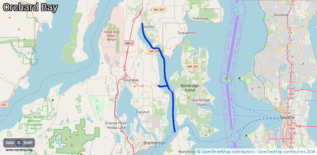
Route:
Please wait, loading route graphic...
Request waterway overview map with symbol legend here (Link).
Information about data associated with this body of water (8 available):
Data by OpenSeaMap (c) OSM contributors, www.openseamap.org
| # | Kind | Coordinates | Name | Information |
|---|---|---|---|---|
| 1 | Marina | 47.65177,-122.61409 | 2021-10-18T00:20:07Z | Port of Brownsville Marina https://www.portofbrownsville.org/ |
| 2 | Marina | 47.73241,-122.64797 | 2025-04-27T22:52:37Z | Port of Poulsbo Marina Mo-Fr 08:00-16:30, Sa-Su off, Jan 01 off, Nov Th[4] off, Dec 25-26 off [email protected] +1-360-779-3505 https://portofpoulsbo.com |
| 3 | Marina | 47.73362,-122.6475 | 2026-01-23T18:06:36Z | |
| 4 | Marina | 47.73291,-122.64647 | 2026-01-23T18:06:36Z | |
| 5 | Marina | 47.72662,-122.64402 | 2025-03-05T21:37:27Z | |
| 6 | Slipway | 47.65197,-122.61614 | small_craft_facility | 2025-11-27T10:59:30Z by car |
| 7 | Slipway | 47.65202,-122.61613 | small_craft_facility | 2025-11-27T10:59:30Z by car |
| 8 | Slipway | 47.72511,-122.63982 | small_craft_facility | 2025-08-04T06:48:27Z manually |