Waterway information

Kind:
Inland
Driving areas:
🌊 North Sea🇳🇴 Norway
Length:
13.6 km¹
¹River kilometers or bank length recorded in NavShip, including river arms and harbor entrances.
Availability:
Completely recorded
Recent Update: 19.06.2023²
² This date indicates when an adjustment last took place in the course of the body of water
Recorded:
Locks: 0
Harbours / marinas: 8
Bridges: 0
Berths: 0
Slipways: 1
Fuelstations: 0
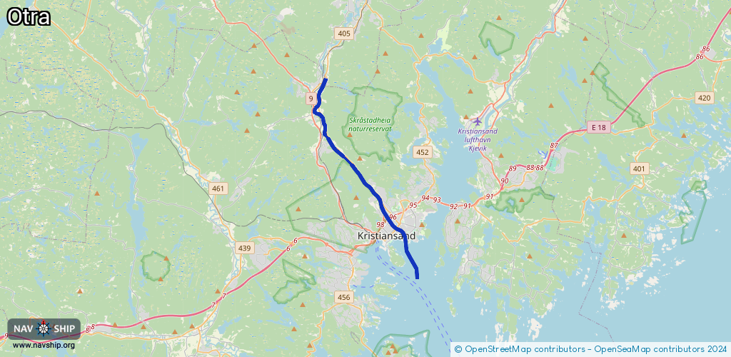
Route:
Please wait, loading route graphic...
Request waterway overview map with symbol legend here (Link).
Information about data associated with this body of water (9 available):
Data by OpenSeaMap (c) OSM contributors, www.openseamap.org
| # | Kind | Coordinates | Name | Information |
|---|---|---|---|---|
| 1 | Marina | 58.14428,8.00245 | 2022-01-07T21:12:25Z | Tresse |
| 2 | Marina | 58.15135,8.00502 | 2022-12-06T14:25:23Z | Kjoita |
| 3 | Marina | 58.14969,8.00389 | 2024-03-01T16:49:16Z | Otra (nedre) |
| 4 | Marina | 58.1449,8.00448 | 2018-07-17T07:47:02Z | Christiansholm |
| 5 | Marina | 58.14865,8.01016 | 2022-03-14T12:37:29Z | Lahelle |
| 6 | Marina | 58.14675,8.01377 | 2018-07-17T07:47:05Z | Prestviga |
| 7 | Marina | 58.14268,8.00065 | 2018-07-17T07:47:01Z | Otterdalen |
| 8 | Marina | 58.14268,8.00233 | 2025-03-22T11:16:39Z | Kristiansand gjestehavn |
| 9 | Slipway | 58.14628,8.00504 | small_craft_facility | 2017-09-11T13:03:53Z |