Waterway information

Kind:
Inland
Driving areas:
🇳🇱 Netherlands
Length:
4.2 km¹
¹River kilometers or bank length recorded in NavShip, including river arms and harbor entrances.
Availability:
Completely recorded
Recent Update: 27.06.2023²
² This date indicates when an adjustment last took place in the course of the body of water
Recorded:
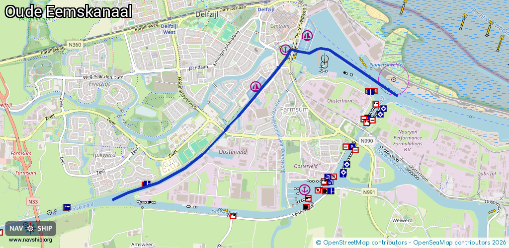
Locks: 1
Harbours / marinas: 3
Bridges: 3
Berths: 0
Slipways: 0
Fuelstations: 0
Route:
Please wait, loading route graphic...
Request waterway overview map with symbol legend here (Link).
Information about data associated with this body of water (7 available):
Data by OpenSeaMap (c) OSM contributors, www.openseamap.org
| # | Kind | Coordinates | Name | Information |
|---|---|---|---|---|
| 1 | Marina | 53.33033,6.93057 | 2023-05-30T12:19:43Z | Jachthaven KZ&RV Neptunus [email protected] +31 596 616 560 http://www.mbv-abeltasman.nl/index.php/nl/ |
| 2 | Marina | 53.32879,6.92709 | 2018-12-27T08:30:23Z | Damsterhaven |
| 3 | Marina | 53.32507,6.92169 | 2013-02-18T13:30:36Z | Jachthaven 't Dok Delfzijl [email protected] |
| 4 | Bridge | 53.3288,6.92847 | 12 | Clearance height: 2022-06-05T13:15:30Z m Maximum passage width: 2.35 m Movable bridge (e.g. lifting bridge or drawbridge) bascule |
| 5 | Bridge | 53.32158,6.91635 | 6 | Clearance height: 2022-06-05T13:15:27Z m Maximum passage width: 2.8 m Movable bridge (e.g. lifting bridge or drawbridge) opening |
| 6 | Bridge | 53.32039,6.91655 | 16 | Clearance height: 2022-06-05T13:15:29Z m Maximum passage width: 1 m Movable bridge (e.g. lifting bridge or drawbridge) opening |
| 7 | Lock | 53.32763,6.92671 | Unknown |