Waterway information

Kind:
Inland
Driving areas:
🌊 Atlantic Ocean🇺🇸 United States of America
Length:
23.6 km¹
¹River kilometers or bank length recorded in NavShip, including river arms and harbor entrances.
Availability:
Completely recorded
Recent Update: 02.04.2024²
² This date indicates when an adjustment last took place in the course of the body of water
Recorded:
Locks: 0
Harbours / marinas: 22
Bridges: 3
Berths: 1
Slipways: 1
Fuelstations: 0
Route:
Please wait, loading route graphic...
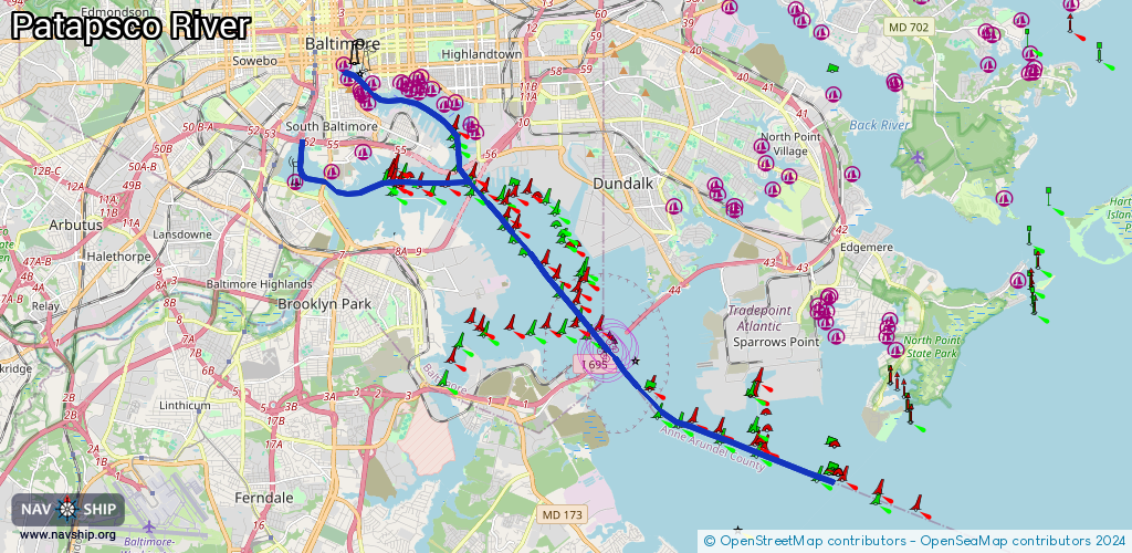
Request waterway overview map with symbol legend here (Link).
Information about data associated with this body of water (27 available):
Data by OpenSeaMap (c) OSM contributors, www.openseamap.org
| # | Kind | Coordinates | Name | Information |
|---|
| 1 | Marina | 39.28586,-76.61033 | 2023-09-12T00:13:43Z | Living Classrooms Paddle Boats |
| 2 | Marina | 39.28232,-76.60849 | 2020-05-19T21:33:26Z | Inner Harbor Marina |
| 3 | Marina | 39.28182,-76.60188 | 2022-04-03T01:33:43Z | Harbor East Marina |
| 4 | Marina | 39.27958,-76.60544 | 2020-05-19T21:33:26Z | Inner Harbor West Marina |
| 5 | Marina | 39.27893,-76.60514 | 2020-05-19T21:33:26Z | |
| 6 | Marina | 39.27834,-76.60473 | 2020-05-19T21:33:26Z | |
| 7 | Marina | 39.2765,-76.60342 | 2020-05-19T21:33:26Z | Harborview Marina |
| 8 | Marina | 39.27999,-76.58994 | 2021-07-28T22:50:02Z | |
| 9 | Marina | 39.28163,-76.59265 | 2022-01-08T21:56:29Z | |
| 10 | Marina | 39.28096,-76.59109 | 2022-01-03T13:58:50Z | |
| 11 | Marina | 39.27947,-76.58726 | 2021-07-28T22:50:02Z | Henderson's Wharf Marina |
| 12 | Marina | 39.2805,-76.58705 | 2021-07-28T22:50:02Z | The Marina at The Crescent |
| 13 | Marina | 39.28239,-76.58789 | 2021-12-26T19:44:19Z | Thames Point Marina |
| 14 | Marina | 39.28298,-76.5864 | 2020-08-15T06:33:46Z | Captain James Restaurant |
| 15 | Marina | 39.28055,-76.58265 | 2020-08-20T04:03:19Z | Anchorage Marina |
| 16 | Marina | 39.27705,-76.5789 | 2020-05-19T21:33:26Z | Lighthouse Point Marina |
| 17 | Marina | 39.27686,-76.57577 | 2020-05-19T21:33:26Z | |
| 18 | Marina | 39.27126,-76.57053 | 2020-05-19T21:33:26Z | Baltimore Marine Centers Yard |
| 19 | Marina | 39.26955,-76.56953 | 2020-05-19T21:33:26Z | Port of Baltimore Small Boat Facility |
| 20 | Marina | 39.25682,-76.62621 | 2020-05-19T21:33:26Z | Middle Branch Marina |
| 21 | Marina | 39.26054,-76.61414 | 2025-06-07T13:58:32Z | |
| 22 | Marina | 39.26473,-76.60436 | 2021-05-20T05:28:40Z | Tidewater Yacht Services Marina |
| 23 | Bridge | 39.26505,-76.6239 | 25.9 | Clearance height: 2023-04-18T14:35:58Z m
Maximum passage width: 2.7 m
swing |
| 24 | Bridge | 39.26504,-76.62386 | 25.9 | Clearance height: 2023-04-18T14:35:58Z m
Maximum passage width: 2.7 m
swing |
| 25 | Bridge | 39.25779,-76.6163 | 45.7 | Clearance height: 2026-02-03T06:29:05Z m
Maximum passage width: 11.5 m
Movable bridge (e.g. lifting bridge or drawbridge)
bascule |
| 26 | Slipway | 39.20881,-76.53264 | Unknown | 2014-06-26T11:29:24Z |
| 27 | Berth | 39.24952,-76.55219 | 2021-04-28T16:48:45Z | Fort McHenry Channel Anchorage Buoy B
anchorage |