Waterway information

Kind:
Inland
Driving areas:
🇺🇸 United States of America
Length:
4.2 km¹
¹River kilometers or bank length recorded in NavShip, including river arms and harbor entrances.
Availability:
Completely recorded
Recent Update: 21.07.2025²
² This date indicates when an adjustment last took place in the course of the body of water
Recorded:
Locks: 0
Harbours / marinas: 7
Bridges: 0
Berths: 0
Slipways: 0
Fuelstations: 5
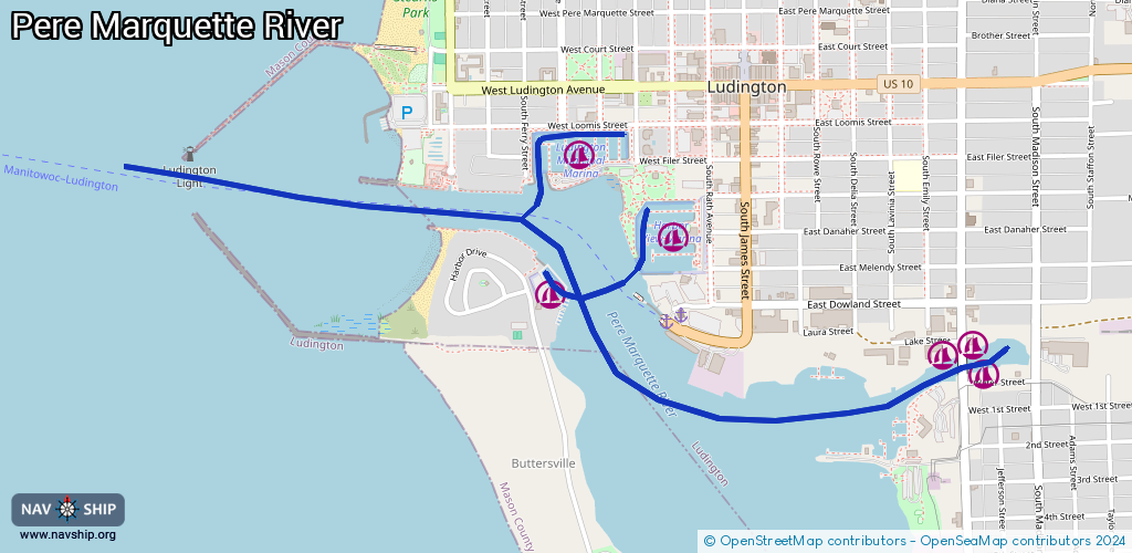
Route:
Please wait, loading route graphic...
Request waterway overview map with symbol legend here (Link).
Information about data associated with this body of water (12 available):
Data by OpenSeaMap (c) OSM contributors, www.openseamap.org
| # | Kind | Coordinates | Name | Information |
|---|---|---|---|---|
| 1 | Marina | 43.95355,-86.45419 | 2021-04-18T01:59:37Z | Ludington Municipal Marina +1 231 843 9611 https://www.ludington.mi.us/220/Municipal-Marina |
| 2 | Marina | 43.9483,-86.43896 | 2024-07-07T03:37:52Z | Ray's Marina |
| 3 | Marina | 43.94748,-86.43855 | 2024-07-07T03:37:52Z | Tamarac Sport Fishing Dock |
| 4 | Marina | 43.94801,-86.44014 | 2024-07-07T03:37:52Z | Lake Street Marina |
| 5 | Marina | 43.94788,-86.44477 | 2025-04-11T18:27:42Z | Ludington Boat Club |
| 6 | Marina | 43.95146,-86.45107 | 2022-12-13T14:53:12Z | Harbor View Marina +1 231 843 6032 http://www.harborviewmarina.com/ |
| 7 | Marina | 43.94959,-86.45537 | 2021-04-17T13:07:15Z | Crosswinds Marina http://www.crosswindsmarinami.com/log_n.cfm?CFID=65347&CFTOKEN=2300e1f2a2ae30dc-BF57E976-163E-F425-BA55708DB61A526F |
| 8 | Fuel station | 43.95394,-86.45554 | 2024-07-07T03:37:52Z | |
| 9 | Fuel station | 43.94767,-86.43798 | 2024-07-07T03:37:52Z | |
| 10 | Fuel station | 43.94827,-86.43854 | 2024-07-07T03:37:52Z | |
| 11 | Fuel station | 43.94783,-86.44018 | 2024-07-07T03:37:52Z | |
| 12 | Fuel station | 43.95037,-86.45029 | 2025-06-04T18:45:45Z | Harbor View Marina |