Waterway information

Kind:
Inland
Driving areas:
🇵🇱 Poland
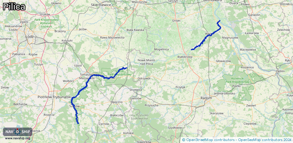
Length:
117.4 km¹
¹River kilometers or bank length recorded in NavShip, including river arms and harbor entrances.
Availability:
Completely recorded
Recent Update: 03.01.2024²
² This date indicates when an adjustment last took place in the course of the body of water
Recorded:
Locks: 0
Harbours / marinas: 4
Bridges: 0
Berths: 0
Slipways: 8
Fuelstations: 0
Route:
Please wait, loading route graphic...
Request waterway overview map with symbol legend here (Link).
Information about data associated with this body of water (12 available):
Data by OpenSeaMap (c) OSM contributors, www.openseamap.org
| # | Kind | Coordinates | Name | Information |
|---|---|---|---|---|
| 1 | Marina | 51.77897,21.18245 | 2024-06-25T13:52:14Z | Przystań Warka |
| 2 | Marina | 51.31909,19.90344 | 2024-06-24T08:41:18Z | Przystań dla kajakarzy |
| 3 | Marina | 51.47342,19.99809 | 2023-06-10T19:59:06Z | Szturnoga M. Port jachtowy Maruś |
| 4 | Marina | 51.47429,19.99841 | 2026-01-04T23:23:17Z | Port jachtowy Młodzieżowego Domu Kultury w Tomaszowie Mazowieckim |
| 5 | Slipway | 51.47327,19.99818 | small_craft_facility | 2026-01-04T23:23:17Z |
| 6 | Slipway | 51.47411,19.99861 | small_craft_facility | 2026-01-04T23:23:17Z |
| 7 | Slipway | 51.46912,20.00976 | small_craft_facility | 2025-09-14T12:15:33Z |
| 8 | Slipway | 51.51736,20.02995 | small_craft_facility | 2025-08-09T13:33:09Z |
| 9 | Slipway | 51.51824,20.03157 | small_craft_facility | 2025-08-09T13:33:09Z |
| 10 | Slipway | 51.51879,20.03248 | small_craft_facility | 2023-01-28T01:14:28Z Miejsce wodowania kajaków |
| 11 | Slipway | 51.51884,20.03247 | small_craft_facility | 2025-09-14T21:32:41Z |
| 12 | Slipway | 51.51887,20.03254 | small_craft_facility | 2025-09-14T21:32:41Z |