Waterway information

Kind:
Inland
Driving areas:
🌊 North Sea🇳🇴 Norway
Length:
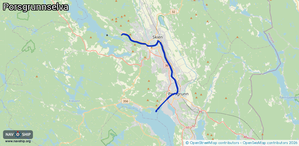
17.5 km¹
¹River kilometers or bank length recorded in NavShip, including river arms and harbor entrances.
Availability:
Completely recorded
Recent Update: 03.02.2025²
² This date indicates when an adjustment last took place in the course of the body of water
Recorded:
Locks: 1
Harbours / marinas: 7
Bridges: 3
Berths: 0
Slipways: 0
Fuelstations: 1
Route:
Please wait, loading route graphic...
Request waterway overview map with symbol legend here (Link).
Information about data associated with this body of water (11 available):
Data by OpenSeaMap (c) OSM contributors, www.openseamap.org
| # | Kind | Coordinates | Name | Information |
|---|---|---|---|---|
| 1 | Marina | 59.2121,9.52311 | 2019-09-21T07:36:55Z | Løveid sluse gjestehavn |
| 2 | Marina | 59.20559,9.60738 | 2019-09-21T07:36:55Z | Hjellebrygga gjestehavn |
| 3 | Marina | 59.20441,9.60688 | 2023-05-10T08:28:56Z | Hjellebrygga |
| 4 | Marina | 59.20561,9.61101 | 2019-09-21T07:36:55Z | Langbryggene gjestehavn |
| 5 | Marina | 59.14197,9.65419 | 2019-09-21T07:36:55Z | Porsgrunn gjestebrygge |
| 6 | Marina | 59.13862,9.63967 | 2019-09-21T07:36:55Z | Down Town gjestebrygge |
| 7 | Marina | 59.13413,9.6307 | 2019-09-21T07:36:55Z | Esso Servicenter |
| 8 | Bridge | 59.21169,9.52261 | Unknown | Clearance height: 2023-04-17T09:16:01Z m Maximum passage width: 4.9 m Movable bridge (e.g. lifting bridge or drawbridge) bascule |
| 9 | Bridge | 59.19917,9.58227 | Unknown | Clearance height: 2023-04-17T09:16:01Z m Maximum passage width: 16 m Movable bridge (e.g. lifting bridge or drawbridge) fixed |
| 10 | Bridge | 59.20426,9.60915 | Unknown | Clearance height: 2023-04-17T09:16:01Z m Movable bridge (e.g. lifting bridge or drawbridge) bascule |
| 11 | Fuel station | 59.13397,9.63076 | 2019-09-21T07:36:55Z | Esso Brua |
| 11 | Fuel station | 59.13397,9.63076 | 2019-09-21T07:36:55Z | Esso Brua |