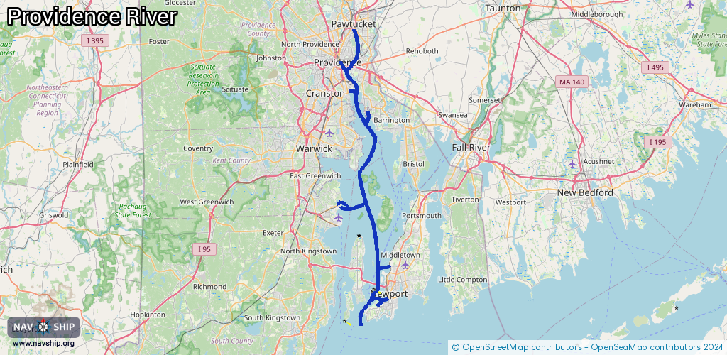
Waterway information

Kind:
Inland
Driving areas:
🌊 Atlantic Ocean🇺🇸 United States of America
Length:
69.9 km¹
¹River kilometers or bank length recorded in NavShip, including river arms and harbor entrances.
Availability:
Completely recorded
Recent Update: 07.04.2025²
² This date indicates when an adjustment last took place in the course of the body of water
Recorded:
Locks: 0
Harbours / marinas: 17
Bridges: 0
Berths: 13
Slipways: 2
Fuelstations: 0
Route:
Please wait, loading route graphic...
Request waterway overview map with symbol legend here (Link).
Information about data associated with this body of water (32 available):
Data by OpenSeaMap (c) OSM contributors, www.openseamap.org
| # | Kind | Coordinates | Name | Information |
|---|---|---|---|---|
| 1 | Marina | 41.81812,-71.38611 | 2023-10-04T13:15:20Z | |
| 2 | Marina | 41.81672,-71.38682 | 2025-08-06T07:44:54Z | |
| 3 | Marina | 41.50555,-71.32595 | 2023-01-13T10:56:58Z | Coasters Harbor Island Marina https://www.navymwrnewport.com/programs/e0ca7e5d-e57f-4f35-b428-0aa72906553c |
| 4 | Marina | 41.46223,-71.36007 | 2022-05-28T23:18:30Z | |
| 5 | Marina | 41.81765,-71.40258 | 2021-11-20T08:48:26Z | |
| 6 | Marina | 41.78274,-71.39104 | 2022-02-14T22:36:30Z | Port Edgewood Marina |
| 7 | Marina | 41.62033,-71.40871 | 2023-04-16T23:00:59Z | The Marina |
| 8 | Marina | 41.61985,-71.41175 | 2023-01-02T23:05:55Z | Allen Harbor Marina https://www.northkingstown.org/425/Allen-Harbor-Marina |
| 9 | Marina | 41.61947,-71.41507 | 2023-01-02T23:05:55Z | Safe Harbor Allen Harbor https://shmarinas.com/locations/safe-harbor-allen-harbor/ |
| 10 | Marina | 41.61841,-71.4151 | 2023-01-02T23:05:55Z | Quonset Davisville Navy Yacht Club https://www.qdnyc.com/ |
| 11 | Marina | 41.747,-71.35637 | 2025-01-22T02:44:37Z | |
| 12 | Marina | 41.74688,-71.3521 | 2025-12-29T18:01:33Z | |
| 13 | Marina | 41.75154,-71.35205 | 2025-11-09T06:52:44Z | Brewer's Cove Haven Marina +1 401-246-1600 |
| 14 | Marina | 41.47311,-71.33763 | 2023-01-06T10:39:48Z | Sail Newport https://sailnewport.org/ |
| 15 | Marina | 41.4888,-71.31908 | 2026-01-27T13:47:52Z | Newport Yacht Club |
| 16 | Marina | 41.4817,-71.31559 | 2022-07-31T15:22:09Z | Newport Marina +1-401-849-2293 |
| 17 | Marina | 41.48695,-71.31713 | 2026-02-08T22:52:53Z | Bowen's Wharf Marina |
| 18 | Slipway | 41.50499,-71.32731 | small_craft_facility | 2023-01-12T21:22:20Z |
| 19 | Slipway | 41.53493,-71.31364 | small_craft_facility | 2023-01-13T21:59:56Z Stillwater Basin |
| 20 | Berth | 41.50854,-71.33862 | 2018-09-16T10:54:16Z | East Passage Anchorage Area C |
| 21 | Berth | 41.48821,-71.33896 | 2018-09-16T10:41:39Z | East Passage Anchorage Area D unrestricted |
| 22 | Berth | 41.48712,-71.36159 | 2021-07-31T00:09:37Z | East Passage Anchorage Area A |
| 23 | Berth | 41.5288,-71.31305 | 2023-01-14T09:19:46Z | USCGC Ida Lewis Idawalley Zorada Lewis, one of a number of women lighthouse keepers. Ida made her first rescue at the age of 16, and went on to carry out as many as 24 documented rescues. After her death, the Lime Rock Lighthouse was renamed Ida Lewis Lighthouse. |
| 24 | Berth | 41.53033,-71.31347 | 2023-01-14T09:19:46Z | USCGC Sycamore |
| 25 | Berth | 41.5296,-71.31321 | 2023-01-14T09:19:46Z | USCGC Oak |
| 26 | Berth | 41.53012,-71.31629 | 2023-01-14T09:19:46Z | NOAAS Henry B. Bigelow Henry B. Bigelow conducts both acoustic and trawl surveys. For its acoustic surveys, the ship uses a vertical beam echo sounder (VBES) and a multibeam echo sounder (MBES) to study of fish and plankton biomass. |
| 27 | Berth | 41.53035,-71.3152 | 2023-01-14T09:19:46Z | USCGC Tiger Shark A multi-mission vessel, capable of performing search and rescue, law enforcement, fishery patrols, drug interdiction, illegal immigrant interdiction, and homeland security duties up to 200 miles offshore. |
| 28 | Berth | 41.52956,-71.3189 | 2023-01-14T09:19:46Z | USCGC Tahoma U.S. Coast Guard cutters patrol the offshore waters from Maine to Florida, Gulf of Mexico, and Caribbean Sea. Missions include Law Enforcement, Search and Rescue, Homeland Security and Defense Operations. |
| 29 | Berth | 41.53005,-71.31909 | 2023-01-14T09:19:46Z | USCGC Campbell U.S. Coast Guard cutters patrol the offshore waters from Maine to Florida, Gulf of Mexico, and Caribbean Sea. Missions include Law Enforcement, Search and Rescue, Homeland Security and Defense Operations. |
| 30 | Berth | 41.62286,-71.41371 | 2023-01-02T23:05:55Z | Allen Harbor Anchorage small_craft_mooring |
| 31 | Berth | 41.48586,-71.32152 | 2018-09-16T10:41:39Z | Newport Rhode Island Anchorage Area Number 2 |
| 32 | Berth | 41.61406,-71.40796 | 2023-01-14T09:19:46Z | NOAAS Okeanos Explorer NOAA Ship Okeanos Explorer is America's ship for ocean exploration. Dedicated to exploration and discovery, Okeanos Explorer maps the seafloor, explores shipwrecks, and characterizes largely unknown areas of the ocean. |