Waterway information

Kind:
Inland
Driving areas:
🇫🇷 France
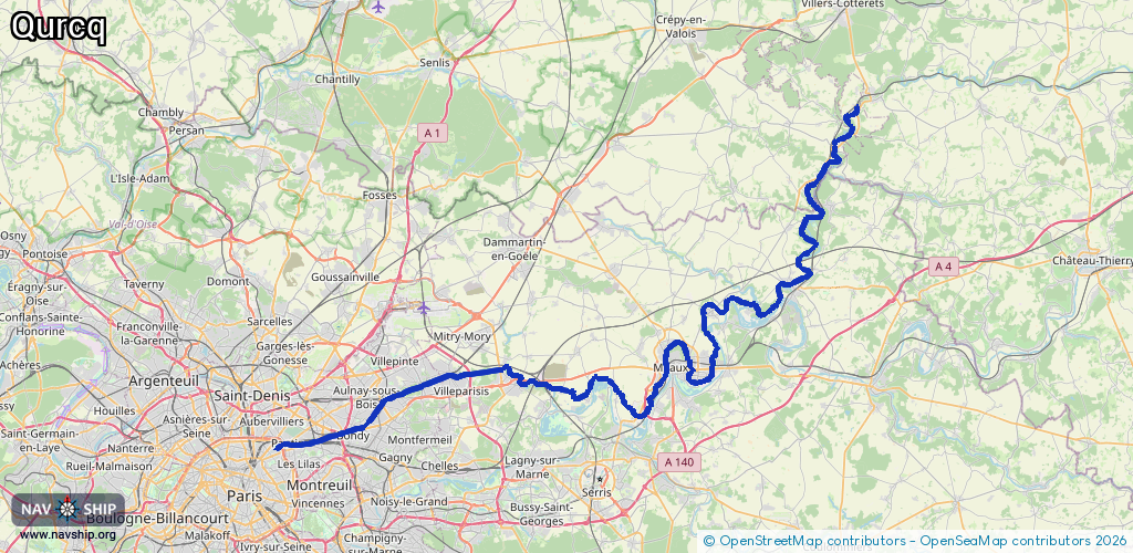
Length:
100.8 km¹
¹River kilometers or bank length recorded in NavShip, including river arms and harbor entrances.
Availability:
Completely recorded
Recent Update: 23.09.2021²
² This date indicates when an adjustment last took place in the course of the body of water
Recorded:
Locks: 9
Harbours / marinas: 2
Bridges: 0
Berths: 0
Slipways: 0
Fuelstations: 1
Route:
Please wait, loading route graphic...
Request waterway overview map with symbol legend here (Link).
Information about data associated with this body of water (12 available):
Data by OpenSeaMap (c) OSM contributors, www.openseamap.org
| # | Kind | Coordinates | Name | Information |
|---|---|---|---|---|
| 1 | Marina | 48.93326,2.52735 | 2024-03-12T21:10:43Z | Gare d'eau de Sevran |
| 2 | Marina | 48.90515,2.47073 | 2020-10-02T18:04:33Z | Port de Noisy |
| 3 | Fuel station | 48.89605,2.42393 | 2025-07-04T21:43:34Z | |
| 4 | Lock | 49.16942,3.10788 | Unknown | |
| 5 | Lock | 49.15406,3.10201 | Unknown | |
| 6 | Lock | 49.14132,3.08022 | Unknown | |
| 7 | Lock | 49.00501,2.91742 | Unknown | |
| 8 | Lock | 48.95516,2.9017 | Unknown | |
| 9 | Lock | 48.94947,2.86749 | Unknown | |
| 10 | Lock | 48.93388,2.81671 | Unknown | |
| 11 | Lock | 48.93906,2.75616 | Unknown | |
| 12 | Lock | 48.93297,2.52557 | Unknown |