Waterway information

Kind:
Inland
Driving areas:
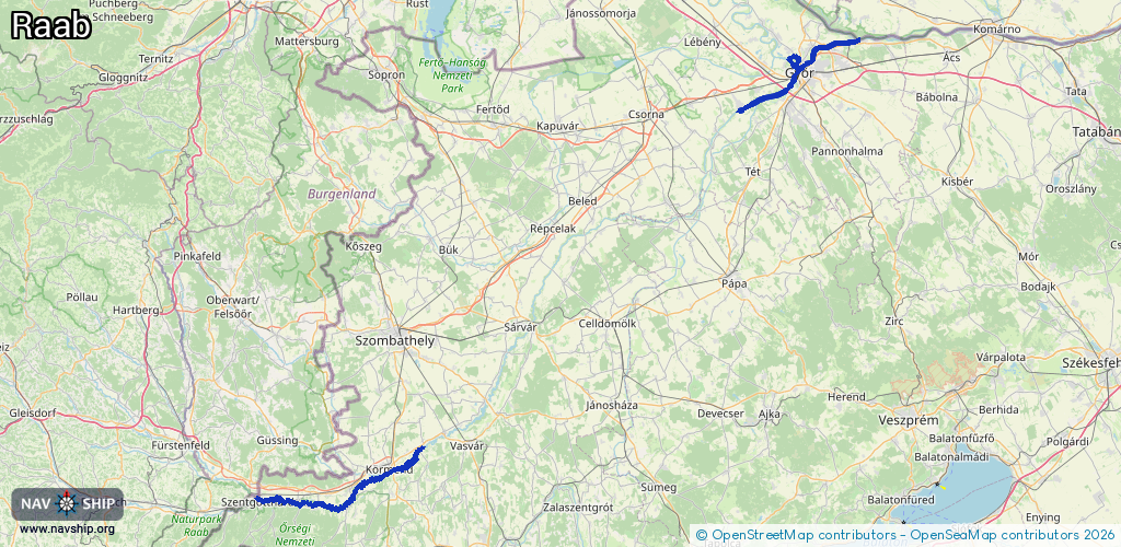
🇦🇹 Austria🇭🇺 Hungary🇸🇰 Slovakia
Length:
99.2 km¹
¹River kilometers or bank length recorded in NavShip, including river arms and harbor entrances.
Availability:
Completely recorded
Recent Update: 11.02.2025²
² This date indicates when an adjustment last took place in the course of the body of water
Recorded:
Locks: 1
Harbours / marinas: 5
Bridges: 0
Berths: 0
Slipways: 0
Fuelstations: 0
Route:
Please wait, loading route graphic...
Request waterway overview map with symbol legend here (Link).
Information about data associated with this body of water (5 available):
Data by OpenSeaMap (c) OSM contributors, www.openseamap.org
| # | Kind | Coordinates | Name | Information |
|---|---|---|---|---|
| 1 | Marina | 46.99853,16.5902 | 2020-10-10T12:19:27Z | átemelő hely, vízreszállás http://users.atw.hu/viziterkep/raba.htm |
| 2 | Marina | 46.99861,16.5895 | 2020-10-10T12:19:27Z | átemelő hely, vízreszállás http://users.atw.hu/viziterkep/raba.htm |
| 3 | Marina | 46.99827,16.58948 | 2024-08-05T10:11:51Z | átemelő hely, kikötés http://users.atw.hu/viziterkep/raba.htm |
| 4 | Marina | 46.99801,16.58976 | 2020-10-10T12:19:27Z | átemelő hely, kikötés http://users.atw.hu/viziterkep/raba.htm |
| 5 | Marina | 46.95168,16.36622 | 2020-11-15T11:02:42Z | kikötés http://users.atw.hu/viziterkep/raba.htm |
| 5 | Marina | 46.95168,16.36622 | 2020-11-15T11:02:42Z | kikötés http://users.atw.hu/viziterkep/raba.htm |