Waterway information

Kind:
Inland
Driving areas:
🇩🇪 Germany
Length:
4.1 km¹
¹River kilometers or bank length recorded in NavShip, including river arms and harbor entrances.
Availability:
Completely recorded
Recent Update: 30.05.2025²
² This date indicates when an adjustment last took place in the course of the body of water
Recorded:
Locks: 0
Harbours / marinas: 4
Bridges: 4
Berths: 0
Slipways: 0
Fuelstations: 0
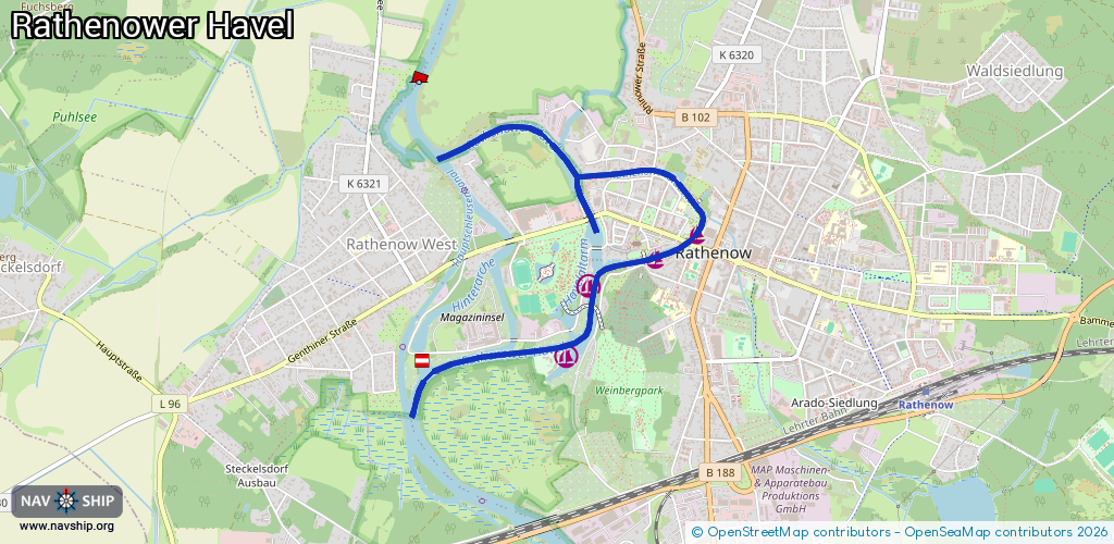
Route:
Please wait, loading route graphic...
Request waterway overview map with symbol legend here (Link).
Information about data associated with this body of water (8 available):
Data by OpenSeaMap (c) OSM contributors, www.openseamap.org
| # | Kind | Coordinates | Name | Information |
|---|---|---|---|---|
| 1 | Marina | 52.60732,12.3369 | 2013-01-12T13:12:04Z | Anleger Stadtschleuse |
| 2 | Marina | 52.60614,12.33366 | 2023-10-21T08:43:18Z | Liegestelle Sportboote Strom, Trinkwasser 0,03 Cent Liter, SB Fäkalienentsorgung Stand: 2023 |
| 3 | Marina | 52.60476,12.32837 | 2023-02-03T20:27:57Z | KWTC Rathenow e.V. [email protected] +49 174 3617119,+49 172 6189781 |
| 4 | Marina | 52.60139,12.32661 | 2013-01-12T12:58:26Z | Rathenower Wassersportverein Segeln 1922 14-JUL-08 14:11:51 [email protected] +49 177 3415768 http://www.rws1922.de http://www.rws1922.de |
| 5 | Bridge | 52.61032,12.33352 | 9.50 | Clearance height: 2022-08-13T08:05:54Z m Maximum passage width: 3.98 m Movable bridge (e.g. lifting bridge or drawbridge) fixed |
| 6 | Bridge | 52.60688,12.33614 | 8.56 | Clearance height: 2021-01-24T20:07:01Z m Maximum passage width: 5.71 m Movable bridge (e.g. lifting bridge or drawbridge) fixed |
| 7 | Bridge | 52.6061,12.33285 | 21.50 | Clearance height: 2018-11-28T18:29:17Z m Maximum passage width: 4.64 m Movable bridge (e.g. lifting bridge or drawbridge) fixed |
| 8 | Bridge | 52.60805,12.3286 | Unknown | Clearance height: 2022-08-15T16:32:29Z m Maximum passage width: 4 m Movable bridge (e.g. lifting bridge or drawbridge) fixed |