Waterway information

Kind:
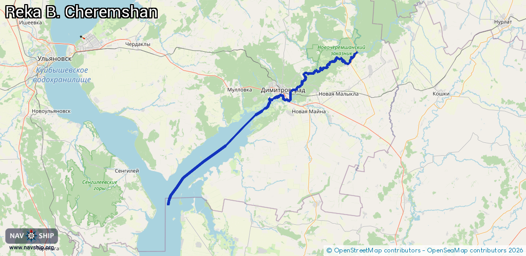
Inland
Driving areas:
🇷🇺 Russia
Length:
110.1 km¹
¹River kilometers or bank length recorded in NavShip, including river arms and harbor entrances.
Availability:
Completely recorded
Recent Update: 01.04.2025²
² This date indicates when an adjustment last took place in the course of the body of water
Recorded:
Locks: 0
Harbours / marinas: 4
Bridges: 3
Berths: 0
Slipways: 0
Fuelstations: 0
Route:
Please wait, loading route graphic...
Request waterway overview map with symbol legend here (Link).
Information about data associated with this body of water (7 available):
Data by OpenSeaMap (c) OSM contributors, www.openseamap.org
| # | Kind | Coordinates | Name | Information |
|---|---|---|---|---|
| 1 | Marina | 54.20138,49.60703 | 2021-01-17T08:48:17Z | Мистер Галс +7 (84235) 53959 |
| 2 | Marina | 54.21039,49.66241 | 2021-01-17T09:00:24Z | Лодочная станция № 3 |
| 3 | Marina | 54.18915,49.55073 | 2021-05-18T11:52:43Z | |
| 4 | Marina | 54.19716,49.59208 | 2026-01-15T17:11:43Z | Нептун-Аква +7 (84235) 2-97-72 |
| 5 | Bridge | 54.24623,49.73791 | Unknown | Clearance height: 2022-11-28T18:56:20Z m fixed |
| 6 | Bridge | 54.20272,49.66521 | Unknown | Clearance height: 2025-12-08T08:33:13Z m fixed |
| 7 | Bridge | 54.183,49.65692 | Unknown | Clearance height: 2022-09-17T17:35:16Z m fixed |