Waterway information

Kind:
Inland
Driving areas:
🇩🇪 Germany
Length:
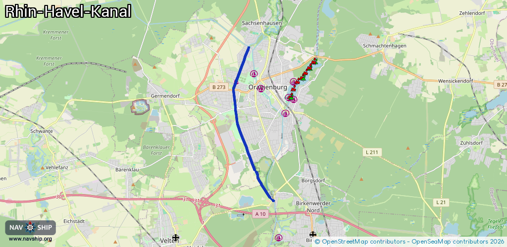
7.8 km¹
¹River kilometers or bank length recorded in NavShip, including river arms and harbor entrances.
Availability:
Completely recorded
Recent Update: 18.02.2025²
² This date indicates when an adjustment last took place in the course of the body of water
Recorded:
Locks: 0
Harbours / marinas: 1
Bridges: 6
Berths: 0
Slipways: 0
Fuelstations: 0
Route:
Please wait, loading route graphic...
Request waterway overview map with symbol legend here (Link).
Information about data associated with this body of water (7 available):
Data by OpenSeaMap (c) OSM contributors, www.openseamap.org
| # | Kind | Coordinates | Name | Information |
|---|---|---|---|---|
| 1 | Marina | 52.75549,13.22382 | 2014-07-07T13:29:26Z | Stadtanleger Mülltonne, Neues Bollwerk bis 4,3m Breite |
| 2 | Bridge | 52.75495,13.2232 | Unknown | Clearance height: 2025-10-17T13:41:15Z m fixed |
| 3 | Bridge | 52.75168,13.22169 | Unknown | Clearance height: 2015-05-18T14:40:55Z m fixed |
| 4 | Bridge | 52.7436,13.22317 | Unknown | Clearance height: 2015-05-18T14:41:18Z m Movable bridge (e.g. lifting bridge or drawbridge) fixed |
| 5 | Bridge | 52.74203,13.22346 | Unknown | Clearance height: 2015-05-18T14:41:18Z m Movable bridge (e.g. lifting bridge or drawbridge) fixed |
| 6 | Bridge | 52.7253,13.232 | Unknown | Clearance height: 2019-03-28T15:55:11Z m Maximum passage width: 3.75 m Movable bridge (e.g. lifting bridge or drawbridge) fixed |
| 7 | Bridge | 52.70532,13.24884 | Unknown | Clearance height: 2012-11-03T15:13:00Z m Maximum passage width: 4.3 m Movable bridge (e.g. lifting bridge or drawbridge) fixed |