Waterway information

Kind:
Inland
Driving areas:
🌊 Atlantic Ocean🇪🇸 Spain
Length:
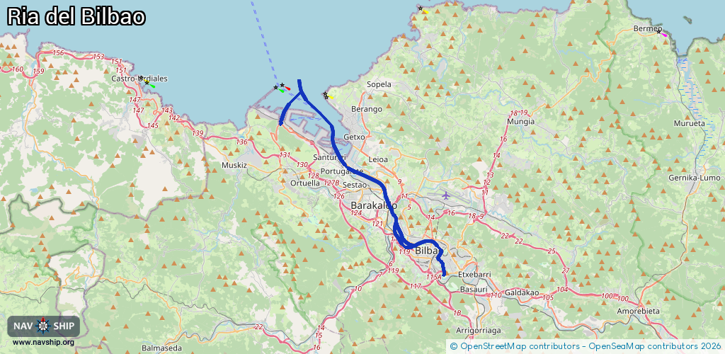
27.9 km¹
¹River kilometers or bank length recorded in NavShip, including river arms and harbor entrances.
Availability:
Completely recorded
Recent Update: 15.04.2025²
² This date indicates when an adjustment last took place in the course of the body of water
Recorded:
Locks: 0
Harbours / marinas: 8
Bridges: 0
Berths: 0
Slipways: 0
Fuelstations: 0
Route:
Please wait, loading route graphic...
Request waterway overview map with symbol legend here (Link).
Information about data associated with this body of water (8 available):
Data by OpenSeaMap (c) OSM contributors, www.openseamap.org
| # | Kind | Coordinates | Name | Information |
|---|---|---|---|---|
| 1 | Marina | 43.35382,-3.08025 | 2024-02-20T09:32:09Z | Puerto de Zierbena |
| 2 | Marina | 43.35355,-3.07998 | 2021-03-06T21:02:59Z | Puerto Deportivo de Zierbena |
| 3 | Marina | 43.31945,-3.01471 | 2021-12-11T12:24:23Z | Muelle Viejo |
| 4 | Marina | 43.31971,-3.01459 | 2023-10-05T18:13:24Z | Muelle Remolcadores del Puerto de Bilbao |
| 5 | Marina | 43.32974,-3.01568 | 2025-02-02T08:54:39Z | Abrako kirol portua / Puerto Deportivo del Abra |
| 6 | Marina | 43.32987,-3.02759 | 2022-10-10T16:10:21Z | Puerto deportivo de Santurtzi |
| 7 | Marina | 43.33027,-3.03054 | 2024-06-13T20:01:23Z | |
| 8 | Marina | 43.33907,-3.01804 | 2023-01-08T18:00:07Z | Puerto Deportivo Getxo Marina Kaia |