Waterway information

Kind:
Inland
Driving areas:
🇦🇷 Argentina🌊 Atlantic Ocean
Length:
3.7 km¹
¹River kilometers or bank length recorded in NavShip, including river arms and harbor entrances.
Availability:
Completely recorded
Recent Update: 04.03.2025²
² This date indicates when an adjustment last took place in the course of the body of water
Recorded:
Locks: 0
Harbours / marinas: 1
Bridges: 0
Berths: 0
Slipways: 6
Fuelstations: 0
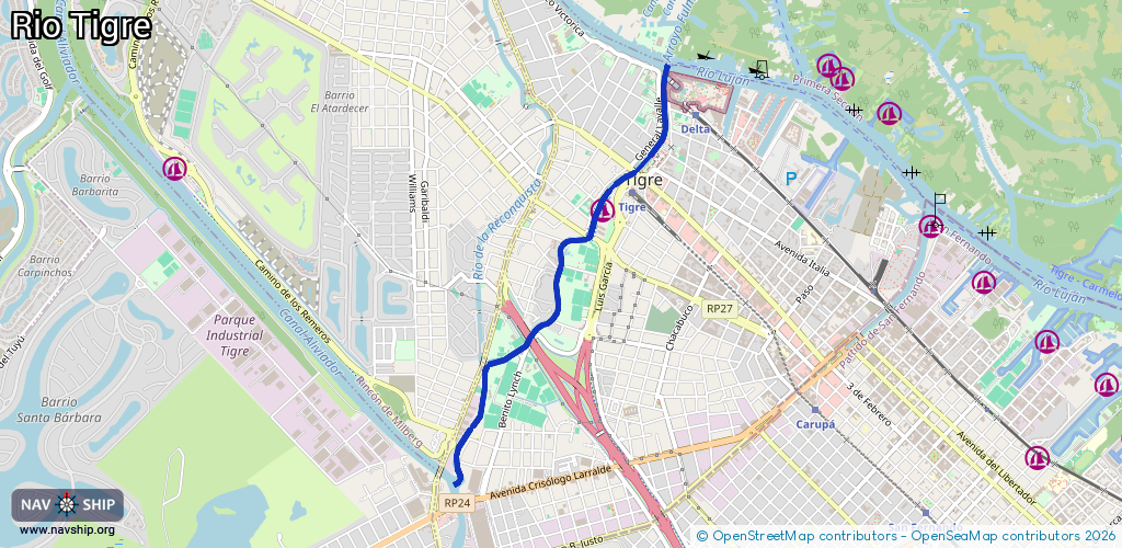
Route:
Please wait, loading route graphic...
Request waterway overview map with symbol legend here (Link).
Information about data associated with this body of water (7 available):
Data by OpenSeaMap (c) OSM contributors, www.openseamap.org
| # | Kind | Coordinates | Name | Information |
|---|---|---|---|---|
| 1 | Marina | -34.42471,-58.58407 | 2021-01-13T18:21:06Z | Amarra publica Hugo del carril |
| 2 | Slipway | -34.42043,-58.57924 | small_craft_facility | 2025-01-18T05:31:34Z Buenos Aires Rowing Club |
| 3 | Slipway | -34.4189,-58.57885 | small_craft_facility | 2025-01-18T16:34:48Z Club Canottieri Italiani |
| 4 | Slipway | -34.41792,-58.5795 | small_craft_facility | 2025-01-19T05:13:44Z Club de Regatas América |
| 5 | Slipway | -34.41871,-58.57943 | small_craft_facility | 2025-01-18T05:31:34Z Nahuel Rowing Club |
| 6 | Slipway | -34.41712,-58.57955 | small_craft_facility | 2025-01-18T05:31:34Z Club Suizo de Buenos Aires |
| 7 | Slipway | -34.4153,-58.58017 | small_craft_facility | 2025-01-18T16:34:48Z Club de Regatas Hispano Argentino |