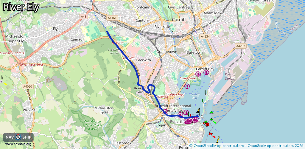
Waterway information

Kind:
Inland
Driving areas:
🌊 Atlantic Ocean🇬🇧 United Kingdom
Length:
6.3 km¹
¹River kilometers or bank length recorded in NavShip, including river arms and harbor entrances.
Availability:
Completely recorded
Recent Update: 05.01.2024²
² This date indicates when an adjustment last took place in the course of the body of water
Recorded:
Locks: 0
Harbours / marinas: 8
Bridges: 0
Berths: 0
Slipways: 0
Fuelstations: 0
Route:
Please wait, loading route graphic...
Request waterway overview map with symbol legend here (Link).
Information about data associated with this body of water (8 available):
Data by OpenSeaMap (c) OSM contributors, www.openseamap.org
| # | Kind | Coordinates | Name | Information |
|---|---|---|---|---|
| 1 | Marina | 51.44831,-3.18634 | 2025-02-28T23:51:14Z | Cardiff Marina |
| 2 | Marina | 51.4474,-3.17771 | 2025-03-05T01:34:00Z | Cardiff Bay Yacht Club |
| 3 | Marina | 51.44502,-3.17479 | 2025-02-25T17:07:31Z | Inner Basin |
| 4 | Marina | 51.44818,-3.17507 | 2026-01-03T13:23:51Z | Cardiff Bay Yacht Club Club House |
| 5 | Marina | 51.44533,-3.17204 | 2025-06-24T23:25:13Z | Penarth Marina |
| 6 | Marina | 51.4452,-3.17298 | 2025-02-25T16:44:59Z | Portway Marina |
| 7 | Marina | 51.44555,-3.17036 | 2025-02-25T17:07:31Z | Outer Basin |
| 8 | Marina | 51.44562,-3.16909 | 2025-02-25T10:43:54Z | Penarth Marina Office |